![Alberto Beingolea: “If they insist on not giving [the powers], they are complicating life for Peru”](https://insightermedia.com/wp-content/uploads/2026/09/bb3fa9e11304ea13fe2cd333955007bc-150x150.webp "Alberto Beingolea: “If they insist on not giving [the powers], they are complicating life for Peru”")



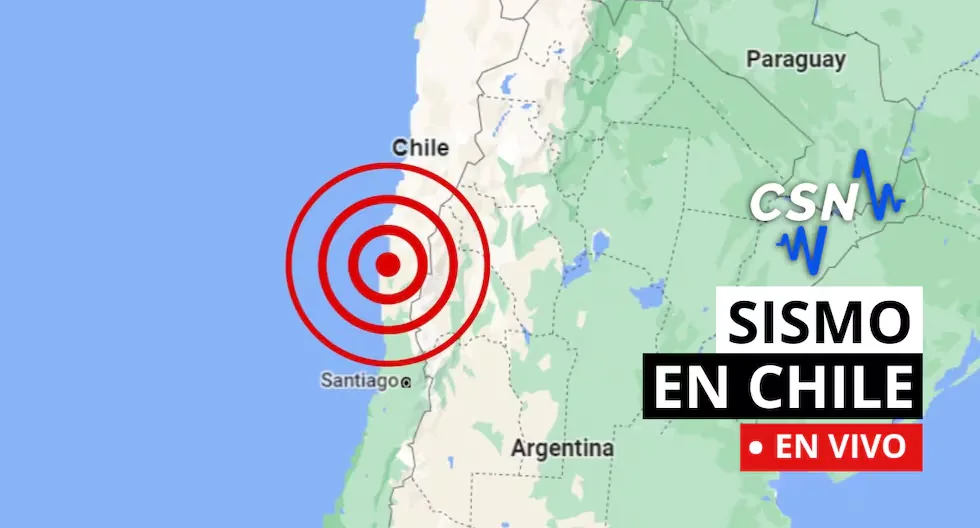
Earthquakes in Chile via the CSN
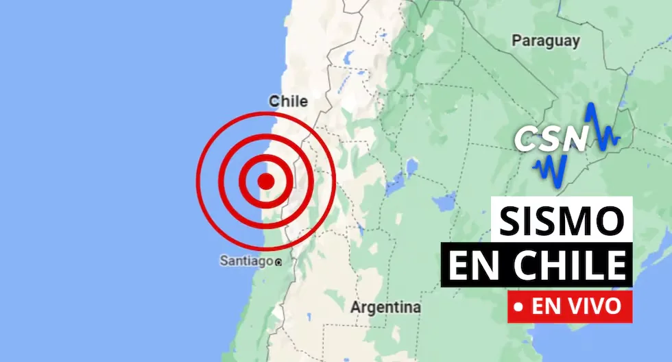
Follow live reports of earthquakes in Chile, according to the National Seismological Center (CSN). You can also check related news, as well as recommendations for these types of situations.
Read more Do you take B Complex? These are the types of vitamin B that exist and what they are for
- WHAT TO DO IN CASE OF A TSUNAMI?
- If you receive official tsunami alert or alarm information or see the sea receding, evacuate to higher areas. Move to a flood-free zone and head to the nearest meeting point. If you cannot reach a higher area, go to an upper floor or the roof of a solid building.
- Earthquake 56 km S of Caldera
- Local Time: 15:52:11 20/08/2026
- Latitude: -27.54
- Longitude: -71.00
- Depth: 32 KM
- Magnitude: 3.6 MLv
- Earthquake 35 km S of Mina Collahuasi
- Local Time: 15:38:05 20/08/2026
- Latitude: -21.13
- Longitude: -68.59
- Depth: 136 KM
- Magnitude: 2.5 MLv
- Earthquake 21 km W of Quintero
- Local Time: 14:30:15 20/08/2026
- Latitude: -32.81
- Longitude: -71.74
- Depth: 26 KM
- Magnitude: 2.5 MLv
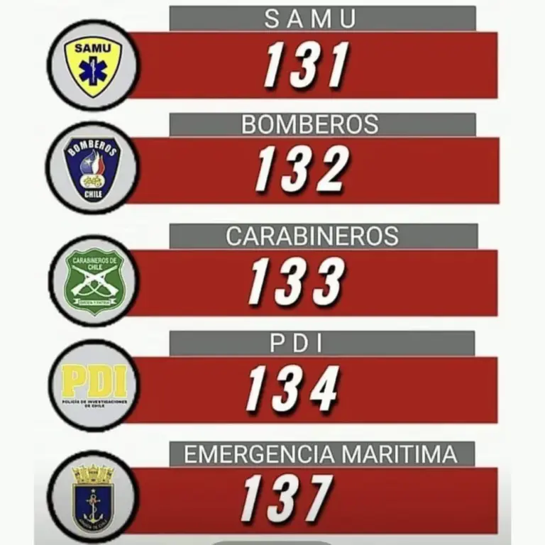
- CHECK AND NOTE EMERGENCY ASSISTANCE NUMBERS.
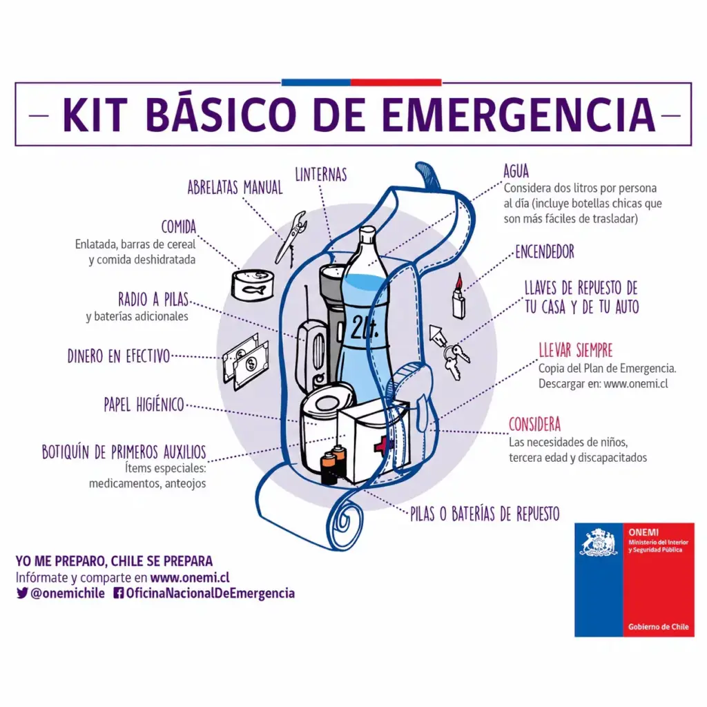
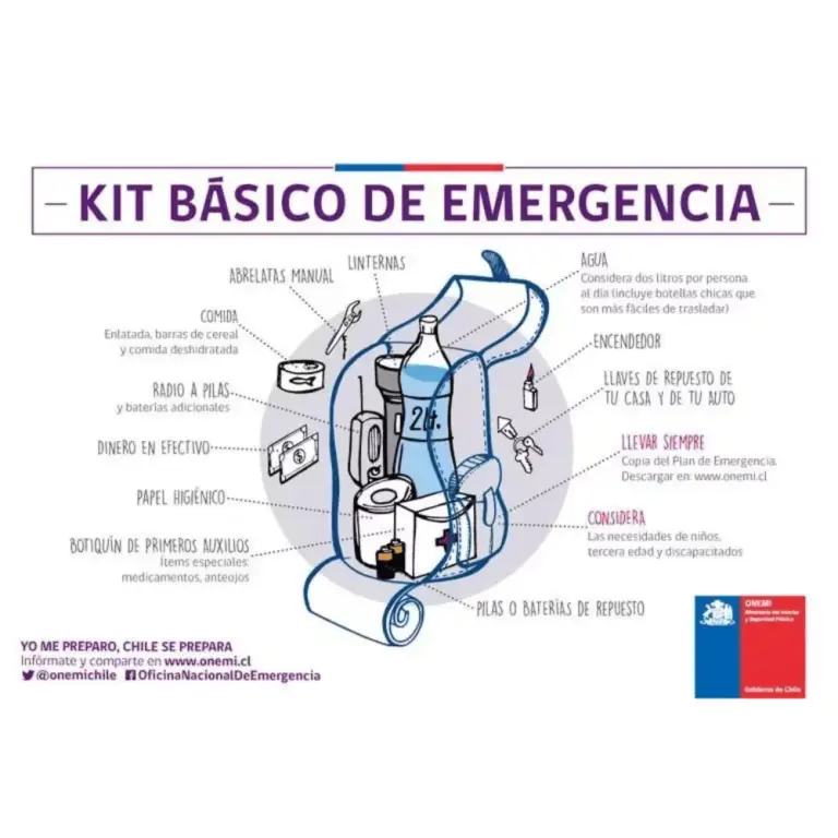
- WHAT SHOULD MY EMERGENCY BACKPACK CONTAIN?
- • Essential hygiene items
- • First aid kit (bandages, gauze, alcohol, pills, hydrogen peroxide, etc.)
- • Warm clothing
- • Non-perishable food (tuna cans, cereal bars, chocolates, nuts, etc.) and money
- • Communication items
- • Specific items for babies and infants, feminine hygiene, elderly care, and other basic needs.
- CHECK WHAT A HOME EMERGENCY BACKPACK SHOULD CONTAIN.
- Earthquake 54 km N of Mina La Escondida
- Local Time: 12:16:27 20/08/2026
- Latitude: -23.79
- Longitude: -68.95
- Depth: 94 KM
- Magnitude: 3.2 MLv
- Earthquake 19 km SW of Pozo Almonte
- Local Time: 11:51:21 20/08/2026
- Latitude: -20.34
- Longitude: -69.94
- Depth: 53 KM
- Magnitude: 3.3 MLv
- Earthquake 34 km SE of Pica
- Local Time: 11:12:00 20/08/2026
- Latitude: -20.66
- Longitude: -69.06
- Depth: 92 KM
- Magnitude: 2.5 MLv
- Earthquake 24 km N of Punta de Choros
- Local Time: 09:54:36 20/08/2026
- Latitude: -29.04
- Longitude: -71.39
- Depth: 36 KM
- Magnitude: 3.5 MLv
- Earthquake 46 km S of Pica
- Local Time: 09:39:20 20/08/2026
- Latitude: -20.89
- Longitude: -69.25
- Depth: 112 KM
- Magnitude: 2.8 MLv
- Earthquake 23 km NE of Punta de Choros
- Local Time: 09:26:50 20/08/2026
- Latitude: -29.06
- Longitude: -71.38
- Depth: 36 KM
- Magnitude: 3.5 MLv
- Earthquake 32 km N of Talca
- Local Time: 06:10:50 20/08/2026
- Latitude: -35.15
- Longitude: -71.74
- Depth: 58 KM
- Magnitude: 3.2 MLv
- Earthquake 28 km E of Tocopilla
- Local Time: 06:03:29 20/08/2026
- Latitude: -22.07
- Longitude: -69.93
- Depth: 76 KM
- Magnitude: 3.4 MLv
- Earthquake 59 km SE of Patache
- Local Time: 03:48:15 20/08/2026
- Latitude: -21.26
- Longitude: -69.91
- Depth: 126 KM
- Magnitude: 4.0 MLv
- Earthquake 36 km NW of La Serena
- Local Time: 02:49:42 20/08/2026
- Latitude: -29.68
- Longitude: -71.52
- Depth: 37 KM
- Magnitude: 2.7 MLv
- Earthquake 45 km NE of Calama
- Local Time: 02:36:40 20/08/2026
- Latitude: -22.28
- Longitude: -68.55
- Depth: 110 KM
- Magnitude: 2.7 MLv
- WHY SHOULD YOU NEVER USE AN ELEVATOR DURING AN EARTHQUAKE?
- Experts recommend never using the elevator during an earthquake or tremor, as it could detach from its structure and fall from a great height with people inside.
- WHAT IS THE DIFFERENCE BETWEEN MAGNITUDE AND INTENSITY OF AN EARTHQUAKE?
- They are scales to measure the size or impact of a tremor. The magnitude scale is obtained numerically from records by seismographs and relates to the size and energy released during a tremor. The intensity scale is assigned based on the damage or effects caused to people and their constructions.
- WHY IS CHILE A HIGHLY SEISMIC COUNTRY?
- Chile is located on the western edge of the South American plate, where the Nazca and Antarctic plates converge and generate earthquakes. This is one of the zones of the Pacific Ring of Fire.
- WHAT IS THE PACIFIC RING OF FIRE?
- The Pacific Ring of Fire is a geologically active region surrounding the Pacific Ocean and the continents that border its waters. It is characterized by a high frequency of earthquakes and volcanic activity. It extends approximately 40,000 kilometers, including subduction zones where tectonic plates collide (such as the Nazca plate), generating frequent volcanoes and earthquakes.
- Earthquake 25 km S of Caleta El Cobre
- Local Time: 00:52:48 20/08/2026
- Latitude: -24.47
- Longitude: -70.56
- Depth: 33 KM
- Magnitude: 4.8 Mw
- Earthquake 49 km SE of Socaire
- Local Time: 00:01:24 20/08/2026
- Latitude: -23.87
- Longitude: -67.53
- Depth: 222 KM
- Magnitude: 3.2 MLv
- Earthquake 98 km NE of El Salvador
- Local Time: 23:36:05 19/08/2026
- Latitude: -25.56
- Longitude: -69.02
- Depth: 96 KM
- Magnitude: 2.6 MLv
- WHAT IS A SEISMIC SWARM?
- A seismic swarm is a group of earthquakes occurring in the same area over a short period. Unlike a single strong earthquake, seismic swarms usually consist of numerous smaller tremors. Often, there is no main earthquake triggering the swarm; instead, seismic events occur more or less continuously and are related to tectonic processes.
- Earthquake 100 km W of San Antonio de los Cobres
- Local Time: 23:09:06 19/08/2026
- Latitude: -24.31
- Longitude: -67.30
- Depth: 197 KM
- Magnitude: 4.8 MLv
- Earthquake 43 km SW of Castro
- Local Time: 22:52:00 19/08/2026
- Latitude: -42.76
- Longitude: -74.12
- Depth: 46 KM
- Magnitude: 3.1 MLv
- HOW TO ACT DURING AN EARTHQUAKE?
- • Go to already established safety zones.
- • Stay away from glass or objects that could fall.
- • Avoid panic if possible and try to stay calm.
- • Do not run in vehicle passage areas.
- • If driving, stop your vehicle.
- • If in a building, do not use the elevator, always use the stairs.
- • Be attentive to minors, disabled, and elderly people.
- Earthquake 19 km SE of San Pedro de Atacama
- Local Time: 22:14:27 19/08/2026
- Latitude: -23.07
- Longitude: -68.11
- Depth: 164 KM
- Magnitude: 3.3 MLv
- HOW TO DIFFERENTIATE A TREMOR FROM AN EARTHQUAKE?
- The terms “tremor” and “earthquake” are often used interchangeably, but generally, the difference lies in their magnitude, perceived intensity, and reach.
- • Tremor: Refers to seismic movements of lesser intensity. Usually used to describe low magnitude earth tremors that do not cause significant damage to structures or people. They are perceptible but have mild impact.
- • Earthquake: Refers to a seismic event of greater magnitude. Earthquakes are significant seismic tremors that can cause severe damage to buildings, infrastructure, and in the most severe cases, cause personal injuries and even loss of life. They have considerable magnitude and are often accompanied by aftershocks.
- WHAT IS THE PACIFIC RING OF FIRE?
- The Pacific Ring of Fire is a geologically active region surrounding the Pacific Ocean and the continents that border its waters. It is characterized by a high frequency of earthquakes and volcanic activity. It extends approximately 40,000 kilometers, including subduction zones where tectonic plates collide (such as the Nazca plate), generating frequent volcanoes and earthquakes.
- WHAT IS AN EARTHQUAKE?
- An earthquake is a sudden rupture of rocks inside the Earth. This sudden release of energy propagates as waves that cause ground movement.
- WHAT TO DO IN CASE OF A TSUNAMI?
- If you receive official tsunami alert or alarm information or see the sea receding, evacuate to higher areas. Move to a flood-free zone and head to the nearest meeting point. If you cannot reach a higher area, go to an upper floor or the roof of a solid building.
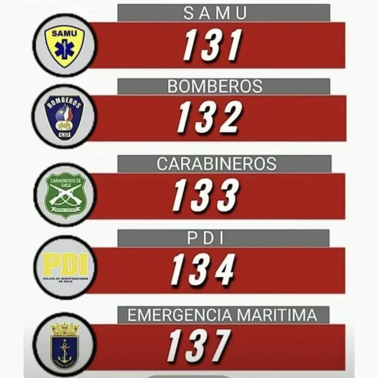
- CHECK AND NOTE EMERGENCY ASSISTANCE NUMBERS.
- WHAT SHOULD MY EMERGENCY BACKPACK CONTAIN?
- • Essential hygiene items
- • First aid kit (bandages, gauze, alcohol, pills, hydrogen peroxide, etc.)
- • Warm clothing
- • Non-perishable food (tuna cans, cereal bars, chocolates, nuts, etc.) and money
- • Communication items
- • Specific items for babies and infants, feminine hygiene, elderly care, and other basic needs.
- CHECK WHAT A HOME EMERGENCY BACKPACK SHOULD CONTAIN.
- WHY SHOULD YOU NEVER USE AN ELEVATOR DURING AN EARTHQUAKE?
- Experts recommend never using the elevator during an earthquake or tremor, as it could detach from its structure and fall from a great height with people inside.
- Earthquake 46 km SW of Mina Collahuasi
- Local Time: 19:33:16 19/08/2026
- Latitude: -21.07
- Longitude: -69.02
- Depth: 109 KM
- Magnitude: 2.5 MLv
- Earthquake 74 km N of Calama
- Local Time: 18:54:01 19/08/2026
- Latitude: -21.82
- Longitude: -68.79
- Depth: 117 KM
- Magnitude: 2.8 MLv
- Earthquake 43 km NE of Punta de Choros
- Local Time: 18:15:34 19/08/2026
- Latitude: -28.90
- Longitude: -71.26
- Depth: 46 KM
- Magnitude: 3.0 MLv
- Earthquake 77 km SW of San Pedro de Atacama
- Local Time: 17:44:21 19/08/2026
- Latitude: -23.43
- Longitude: -68.72
- Depth: 100 KM
- Magnitude: 2.6 MLv
- Earthquake 14 km NW of Punitaqui
- Local Time: 17:18:53 19/08/2026
- Latitude: -30.75
- Longitude: -71.37
- Depth: 44 KM
- Magnitude: 2.6 MLv
- Earthquake 40 km W of Paposo
- Local Time: 16:44:47 19/08/2026
- Latitude: -25.06
- Longitude: -70.85
- Depth: 38 KM
- Magnitude: 3.2 MLv
- Earthquake 89 km SE of Socaire
- Local Time: 16:38:20 19/08/2026
- Latitude: -24.06
- Longitude: -67.19
- Depth: 166 KM
- Magnitude: 3.3 MLv
- Earthquake 29 km S of Pichidangui
- Local Time: 15:05:45 19/08/2026
- Latitude: -32.39
- Longitude: -71.61
- Depth: 35 KM
- Magnitude: 2.5 MLv
- Earthquake 10 km SW of Pichilemu
- Local Time: 14:29:26 19/08/2026
- Latitude: -34.46
- Longitude: -72.08
- Depth: 19 KM
- Magnitude: 2.5 MLv
- Earthquake 25 km E of Talca
- Local Time: 13:58:15 19/08/2026
- Latitude: -35.46
- Longitude: -71.39
- Depth: 91 KM
- Magnitude: 2.8 MLv
- WHAT IS THE DIFFERENCE BETWEEN MAGNITUDE AND INTENSITY OF AN EARTHQUAKE?
- They are scales to measure the size or impact of a tremor. The magnitude scale is obtained numerically from records by seismographs and relates to the size and energy released during a tremor. The intensity scale is assigned based on the damage or effects caused to people and their constructions.
- WHY IS CHILE A HIGHLY SEISMIC COUNTRY?
- Chile is located on the western edge of the South American plate, where the Nazca and Antarctic plates converge and generate earthquakes. This is one of the zones of the Pacific Ring of Fire.
Earthquake 6 km NE of La Serena
Local Time: 13:25:05 19/08/2026
UTC Time: 17:25:05 19/08/2026
Latitude: -29.85
Longitude: -71.23
Depth: 51 km
Magnitude: 4.2 MLv
Earthquake 29 km SE of Pica
Local Time: 11:03:56 19/08/2026
UTC Time: 15:03:56 19/08/2026
Latitude: -20.68
Longitude: -69.14
Depth: 103 km
Magnitude: 2.5 MLv
Earthquake 13 km W of La Higuera
Local Time: 08:52:45 19/08/2026
UTC Time: 12:52:45 19/08/2026
Latitude: -29.55
Longitude: -71.33
Depth: 44 km
Magnitude: 2.6 MLv
Earthquake 58 km S of Mina Collahuasi
Local Time: 08:42:50 19/08/2026
UTC Time: 12:42:50 19/08/2026
Latitude: -21.32
Longitude: -68.83
Depth: 105 km
Magnitude: 2.5 MLv
Earthquake 54 km NE of San Pedro de Atacama
Local Time: 08:15:35 19/08/2026
UTC Time: 12:15:35 19/08/2026
Latitude: -22.52
Longitude: -67.91
Depth: 188 km
Magnitude: 2.5 MLv
Earthquake 46 km SW of Ollagüe
Local Time: 07:33:09 19/08/2026
UTC Time: 11:33:09 19/08/2026
Latitude: -21.55
Longitude: -68.51
Depth: 135 km
Magnitude: 2.8 MLv
Why does the Earth shake?
Because tectonic plates move and accumulate energy. When this energy is suddenly released, an earthquake occurs.
How to prepare before an earthquake?
Conduct drills, have your emergency backpack ready, and plan an evacuation route with your family. Prevention saves lives.
What is the difference between earthquake, tremor, seismic event, and ground movement?
They are synonyms, but in some countries “earthquake” is used for the most destructive seismic events.
What to do if I am on the street when an earthquake starts?
Find an open place away from poles, trees, or buildings. Beware of electrical wires. If driving, stop carefully in a safe place.
How to know if an earthquake is strong?
There are two ways:
– Magnitude, measured on the Richter scale, indicates the energy released.
– Intensity, measured on the Mercalli scale, measures the impact on people and structures.
How to differentiate a tremor from an earthquake?
Both are movements of the Earth, but we usually call “earthquake” those of greater magnitude and destructive impact, while “tremor” is used for milder seismic events.
Why are multiple magnitudes reported for the same earthquake?
Because the first information comes from nearby stations and is adjusted as more data arrives from different sensors. Science continues calculating after the first alert.
How do we know an earthquake will happen?
Earthquakes cannot be predicted, but seismographs and accelerographs detect ground movements in real time to alert us as quickly as possible.
- WHAT IS THE LARGEST MAGNITUDE EARTHQUAKE RECORDED IN CHILE?
- The earthquake on May 22, 1960, recorded in Valdivia with a magnitude of 9.5 is the strongest earthquake recorded in the country.
- WHAT IS THE PACIFIC RING OF FIRE?
- The Pacific Ring of Fire is a geologically active region surrounding the Pacific Ocean and the continents that border its waters. It is characterized by a high frequency of earthquakes and volcanic activity. It extends approximately 40,000 kilometers, including subduction zones where tectonic plates collide (such as the Nazca plate), generating frequent volcanoes and earthquakes.
- WHAT IS SEISMIC SILENCE?
- Seismic silence is a prolonged period without significant seismic activity or intensity in a region, which may indicate the accumulation of tectonic stresses and an increased risk of a future earthquake.
- WHY IS CHILE A HIGHLY SEISMIC COUNTRY?
- Chile is located on the western edge of the South American plate, where the Nazca and Antarctic plates converge and generate earthquakes. This is one of the zones of the Ring of Fire.
- WHAT IS THE DIFFERENCE BETWEEN MAGNITUDE AND INTENSITY OF AN EARTHQUAKE?
- They are scales to measure the size or impact of a tremor. The magnitude scale is obtained numerically from records by seismographs and relates to the size and energy released during a tremor. The intensity scale is assigned based on the damage or effects caused to people and their constructions.
- WHAT TO DO IN CASE OF A TSUNAMI?
- If you receive official tsunami alert or alarm information or see the sea receding, evacuate to higher areas. Move to a flood-free zone and head to the nearest meeting point. If you cannot reach a higher area, go to an upper floor or the roof of a solid building.
Follow live reports of the latest earthquakes in Chile recorded by the National Seismological Center. Also check related news and recommendations on how to act in these types of situations.