![Alberto Beingolea: “If they insist on not giving [the powers], they are complicating life for Peru”](https://insightermedia.com/wp-content/uploads/2026/09/bb3fa9e11304ea13fe2cd333955007bc-150x150.webp "Alberto Beingolea: “If they insist on not giving [the powers], they are complicating life for Peru”")



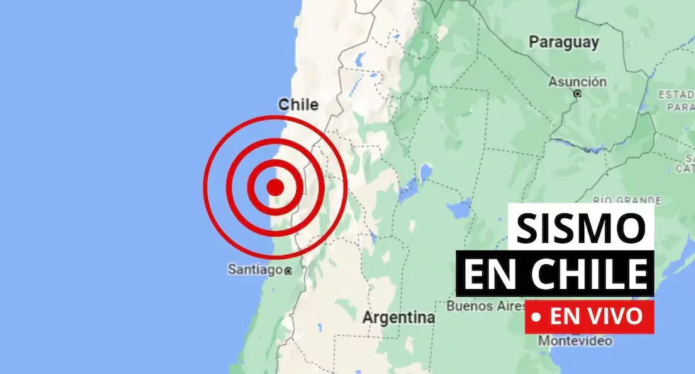
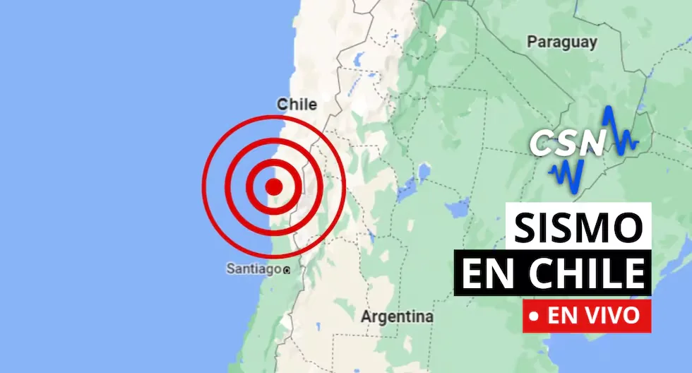
Earthquakes in Chile via the CSN
Follow live reports of earthquakes in Chile, according to the National Seismological Center (CSN). You can also check related news, as well as recommendations for these types of situations.
Read more Dollar price in Peru TODAY, Sunday, August 16: what is the exchange rate
- Earthquake 83 km NE of Paihuano
- Local Time 10:41:40 16/08/2026
- UTC Time 14:41:40 16/08/2026
- Latitude -29.57
- Longitude -69.83
- Depth 126 km
- Magnitude 3.5 MLv
- Earthquake 14 km SE of Ollagüe
- Local Time 10:21:31 16/08/2026
- UTC Time 14:21:31 16/08/2026
- Latitude -21.33
- Longitude -68.17
- Depth 151 km
- Magnitude 3.0 MLv
- Earthquake 58 km SW of Mina La Escondida
- Local Time 09:51:46 16/08/2026
- UTC Time 13:51:46 16/08/2026
- Latitude -24.63
- Longitude -69.47
- Depth 47 km
- Magnitude 2.7 ML
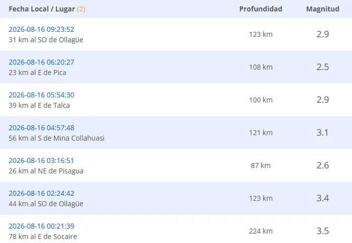
- Earthquake 31 km SW of Ollagüe
- Local Time 09:23:52 16/08/2026
- UTC Time 13:23:52 16/08/2026
- Latitude -21.44
- Longitude -68.44
- Depth 123 km
- Magnitude 2.9 MLv
- UPDATED EARTHQUAKE REPORTS
- Earthquake 36 km N of Farellones
Local Time: 21:45:23 15/08/2026
UTC Time: 01:45:23 16/08/2026
Latitude: -33.03
Longitude: -70.27
Depth: 94 km
Magnitude: 2.7 MLv
- Earthquake 47 km SW of Mina Collahuasi
Local Time: 21:09:59 15/08/2026
UTC Time: 01:09:59 16/08/2026
Latitude: -21.14
Longitude: -68.97
Depth: 114 km
Magnitude: 2.7 MLv
- Earthquake 65 km NE of Mina Collahuasi
Local Time: 21:07:21 15/08/2026
UTC Time: 01:07:21 16/08/2026
Latitude: -20.56
Longitude: -68.10
Depth: 179 km
Magnitude: 2.8 MLv
- Earthquake 65 km E of Quillagua
Local Time: 20:45:36 15/08/2026
UTC Time: 00:45:36 16/08/2026
Latitude: -21.71
Longitude: -68.90
Depth: 91 km
Magnitude: 2.8 MLv
- Earthquake 31 km SW of Camiña
Local Time 20:43:15 15/08/2026
UTC Time 00:43:15 16/08/2026
Latitude -19.45
Longitude -69.69
Depth 81 km
Magnitude 2.9 MLv
- Earthquake 41 km NW of Tongoy
Local Time: 18:22:36 15/08/2026
UTC Time: 22:22:36 15/08/2026
Latitude: -30.00
Longitude: -71.80
Depth: 20 km
Magnitude: 2.5 MLv
- Earthquake 51 km SW of Ollagüe
Local Time: 17:12:57 15/08/2026
UTC Time: 21:12:57 15/08/2026
Latitude: -21.62
Longitude: -68.51
Depth: 128 km
Magnitude: 2.6 MLv
- Earthquake 18 km S of Salamanca
Local Time: 16:51:21 15/08/2026
UTC Time: 20:51:21 15/08/2026
Latitude: -31.94
Longitude: -70.97
Depth: 36 km
Magnitude: 3.3 MLv
- Earthquake 18 km E of Calama
Local Time: 16:07:38 15/08/2026
UTC Time: 20:07:38 15/08/2026
Latitude: -22.47
Longitude: -68.76
Depth: 115 km
Magnitude: 3.2 MLv
- Earthquake 37 km N of Vallenar
Local Time: 15:57:51 15/08/2026
UTC Time:19:57:51 15/08/2026
Latitude: -28.24
Longitude: -70.73
Depth: 75 km
Magnitude: 4.3 MLv
- How much should the survival backpack weigh?
The ideal weight should not exceed 25% of the body weight of the person carrying it, ensuring a quick and agile evacuation.
- Can an earthquake be predicted?
Currently, it is impossible to determine, as the Earth itself has a wide dynamic regarding its movements, considering that it is not only about predicting when it will shake, but also being able to determine the intensity, magnitude, depth, and other important factors.
Earthquake 34 km S of Huasco
- Local Time: 14:15:02 15/08/2026
- UTC Time: 18:15:02 15/08/2026
- Latitude: -28.76
- Longitude: -71.13
- Depth: 42 km
- Magnitude: 2.9 MLv
- Earthquake 7 km W of Pisagua
- Local Time: 13:44:13 15/08/2026
- UTC Time: 17:44:13 15/08/2026
- Latitude: -19.61
- Longitude: -70.28
- Depth: 30 km
- Magnitude: 3.4 MLv
Earthquake 17 km NE of Los Vilos
- Local Time: 13:25:20 15/08/2026
- UTC Time: 17:25:20 15/08/2026
- Latitude: -31.79
- Longitude: -71.39
- Depth: 28 km
- Magnitude: 3.0 MLv
- Earthquake 87 km W of San Antonio de los Cobres
- Local Time: 13:08:06 15/08/2026
- UTC Time: 17:08:06 15/08/2026
- Latitude: -24.06
- Longitude: -67.16
- Depth: 232 km
- Magnitude: 3.8 MLv
- Earthquake 46 km NW of Toltén
- Local Time: 13:03:56 15/08/2026
- UTC Time: 17:03:56 15/08/2026
- Latitude: -38.83
- Longitude: -73.45
- Depth: 10 km
- Magnitude: 3.3 MLv
- Earthquake 48 km S of Mina Collahuasi
- Local Time: 12:46:39 15/08/2026
- UTC Time: 16:46:39 15/08/2026
- Latitude: -21.24
- Longitude: -68.78
- Depth: 130 km
- Magnitude: 2.5 MLv
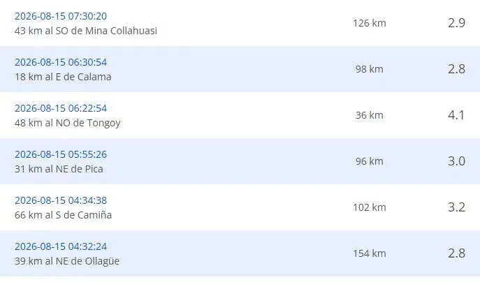
- Earthquake 43 km SW of Mina Collahuasi
- Local Time: 11:56:40 15/08/2026
- UTC Time: 15:56:40 15/08/2026
- Latitude: -21.12
- Longitude: -68.92
- Depth: 115 km
- Magnitude: 2.7 MLv
- Earthquake 89 km SE of Socaire
- Local Time: 11:51:00 15/08/2026
- UTC Time: 15:51:00 15/08/2026
- Latitude: -24.28
- Longitude: -67.45
- Depth: 216 km
- Magnitude: 3.2 MLv
- Earthquake 46 km SW of Ollagüe
- Local Time: 11:14:10 15/08/2026
- UTC Time: 15:14:10 15/08/2026
- Latitude: -21.54
- Longitude: -68.54
- Depth: 116 km
- Magnitude: 2.8 MLv
- Earthquake 22 km SE of Farellones
- Local Time: 11:12:29 15/08/2026
- UTC Time: 15:12:29 15/08/2026
- Latitude: -33.46
- Longitude: -70.11
- Depth: 8 km
- Magnitude: 3.1 MLv
- Earthquake 10 km W of Pichidangui
- Local Time: 09:43:21 15/08/2026
- UTC Time: 13:43:21 15/08/2026
- Latitude: -32.12
- Longitude: -71.64
- Depth: 28 km
- Magnitude: 2.7 MLv
- Earthquake 39 km NE of Calama
- Local Time: 09:33:26 15/08/2026
- UTC Time: 13:33:26 15/08/2026
- Latitude: -22.26
- Longitude: -68.63
- Depth: 109 km
- Magnitude: 2.7 MLv
- Earthquake 43 km S of Pica
- Local Time: 08:53:30 15/08/2026
- UTC Time: 12:53:30 15/08/2026
- Latitude: -20.86
- Longitude: -69.21
- Depth: 113 km
- Magnitude: 3.6 MLv
- Earthquake 56 km SW of Ollagüe
- Local Time: 07:33:40 15/08/2026
- UTC Time: 11:33:40 15/08/2026
- Latitude: -21.44
- Longitude: -68.74
- Depth: 113 km
- Magnitude: 3.6 MLv
Recent earthquakes reported by the CSN.
- WHY IS CHILE A HIGHLY SEISMIC COUNTRY?
Chile is located on the western edge of the South American plate, where the Nazca and Antarctic plates converge and generate earthquakes. This is one of the zones of the Ring of Fire.
- WHAT IS THE LARGEST MAGNITUDE EARTHQUAKE RECORDED IN CHILE?
The earthquake on May 22, 1960, recorded in Valdivia with a magnitude of 9.5 is the strongest earthquake recorded in the country.
Read more Alarm in Loreto: satellite images show the advance of mining dredges in the Amazon
- WHY IS CHILE A HIGHLY SEISMIC COUNTRY?
Chile is located on the western edge of the South American plate, where the Nazca and Antarctic plates converge and generate earthquakes. This is one of the zones of the Ring of Fire.
- WHAT IS THE DIFFERENCE BETWEEN THE MAGNITUDE AND INTENSITY OF AN EARTHQUAKE?
They are scales to measure the size or impact of a tremor. The magnitude scale is obtained numerically from records obtained by seismographs and is related to the size and energy released during a tremor. The intensity scale is assigned based on the damage or effects caused to people and their constructions.
- WHAT TO DO IN CASE OF A TSUNAMI?
If you receive official tsunami alert or alarm information or see the sea receding, evacuate to higher areas. Move to a flood-free zone and head to the nearest meeting point. If you cannot reach a higher area, go to an upper floor or the roof of a solid building.
Read more Channels to watch Barcelona vs Basel: preseason friendly match times
- Follow live reports of the latest earthquakes recorded by the National Seismological Center. Also check related news and recommendations for acting in these types of situations.