






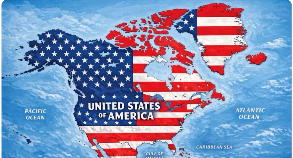
The President of the United States, Donald Trump, shared this Monday on his Truth Social network a map in which the red and white stripes of the American flag cover Mexico, the Caribbean, and Canada, as well as Greenland and Iceland.
Read more ERM 2026: JNE electoral debates begin this Tuesday with candidates from Junín
Trump posted that map without any comment on his Truth Social network, hours after suggesting, on the same social network, that the U.S. state of New Mexico should be renamed and called “New America”, in line with his claim about the “Gulf of America.”
The president usually shares memes and images generated by his supporters or by artificial intelligence on that social network, and the origin of the map he posted this Monday is unclear.
However, the president has made clear in his second term his expansionist ambitions over territories such as Greenland or even Canada, and has not ruled out a military intervention to take Cuba.
Read more “Grand Theft Auto VI” has made a significant change to how weapons work
Without explicitly mentioning the map published by Trump, the president of Mexico, Claudia Sheinbaum, issued a message this Monday on the social network X in which she wanted to make clear that Mexican territory “is not and will not be a colony or protectorate of any foreign country.”
Trump’s map was also revealed days after Trump signed an executive order to rename Lake Ontario, which borders the U.S. and Canada, to “Lake America.”