![Alberto Beingolea: “If they insist on not giving [the powers], they are complicating life for Peru”](https://insightermedia.com/wp-content/uploads/2026/09/bb3fa9e11304ea13fe2cd333955007bc-150x150.webp "Alberto Beingolea: “If they insist on not giving [the powers], they are complicating life for Peru”")



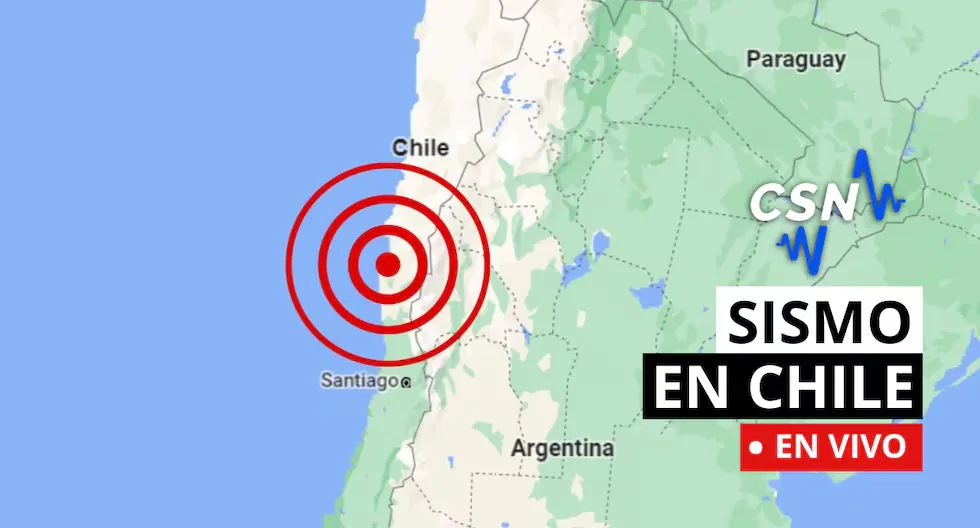
Earthquakes in Chile via the CSN
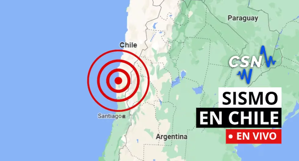
Follow live reports of earthquakes in Chile, according to the National Seismological Center (CSN). You can also check related news, as well as recommendations for these types of situations.
Read more La Tinka TODAY, Sunday, May 31: follow the winning numbers of the Million Jackpot here
- Earthquake 67 km SE of Socaire
Local Time: 11:19:48 31/05/2026
Latitude: -23.93
Longitude: -67.34
Depth: 223 KM
Magnitude: 3.0 MLv
- Earthquake 80 km SE of San José de Maipo
Local Time: 10:35:44 31/05/2026
Latitude: -34.24
Longitude: -69.86
Depth: 16 KM
Magnitude: 2.8 MLv
- Earthquake 32 km SW of Punta de Choros
Local Time: 10:16:22 31/05/2026
Latitude: -29.38
Longitude: -71.76
Depth: 40 KM
Magnitude: 3.9 MLv
- Earthquake 58 km SE of Socaire
Local Time: 09:24:08 31/05/2026
Latitude: -23.97
Longitude: -67.50
Depth: 228 KM
Magnitude: 3.0 MLv
- Earthquake 27 km SE of Arica
Local Time: 09:10:58 31/05/2026
Latitude: -18.60
Longitude: -70.10
Depth: 56 KM
Magnitude: 3.6 MLv
- Earthquake 62 km W of San Antonio de los Cobres
Local Time: 06:56:06 31/05/2026
Latitude: -24.01
Longitude: -66.89
Depth: 204 KM
Magnitude: 3.7 MLv
- Earthquake 41 km NW of Calama
Local Time: 05:33:45 31/05/2026
Latitude: -22.18
Longitude: -69.18
Depth: 84 KM
Magnitude: 3.2 MLv
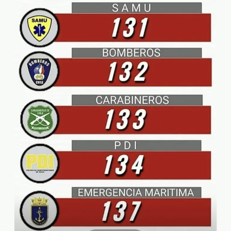
- CHECK AND NOTE EMERGENCY ASSISTANCE NUMBERS.
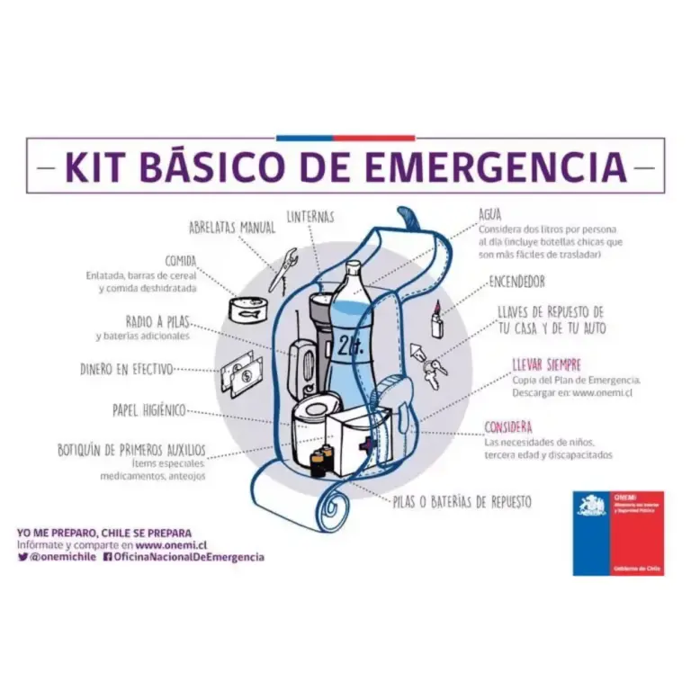
- WHAT SHOULD MY EMERGENCY BACKPACK CONTAIN?
- • Essential hygiene items
- • First aid kit (bandages, gauze, alcohol, pills, hydrogen peroxide, etc.)
- • Warm clothing
- • Non-perishable food (tuna cans, cereal bars, chocolates, nuts, etc.) and money
- • Communication items
- • Specific items for babies and infants, feminine use, elderly, and other basic needs.
- CHECK WHAT AN EMERGENCY BACKPACK FOR THE HOME SHOULD CONTAIN.
- WHY SHOULD YOU NEVER USE AN ELEVATOR DURING AN EARTHQUAKE?
Experts recommend never using the elevator during an earthquake or tremor, as it could detach from its structure and fall from a great height with people inside.
- WHAT IS THE DIFFERENCE BETWEEN MAGNITUDE AND INTENSITY OF AN EARTHQUAKE?
They are scales to measure the size or impact of a tremor. The magnitude scale is obtained numerically from records by seismographs and relates to the size and energy released during a tremor. The intensity scale is assigned based on the damage or effects caused to people and their constructions.
- WHY IS CHILE A HIGHLY SEISMIC COUNTRY?
Chile is located on the western edge of the South American plate, where the Nazca and Antarctic plates converge and generate earthquakes. This is one of the zones of the Ring of Fire.
Earthquake 40 km SE of Arica
Local Time: 22:22:35 30/05/2026
UTC Time: 02:22:35 31/05/2026
Latitude: -18.75
Longitude: -70.06
Depth: 53 km
Magnitude: 3.2 MLv
Earthquake 18 km W of Quintero
Local Time: 22:14:42 30/05/2026
UTC Time: 02:14:42 31/05/2026
Latitude: -32.82
Longitude: -71.71
Depth: 50 km
Magnitude: 4.0 ML
Earthquake 61 km SE of Socaire
Local Time: 20:58:18 30/05/2026
UTC Time: 00:58:18 31/05/2026
Latitude: -24.03
Longitude: -67.54
Depth: 197 km
Magnitude: 3.4 MLv
Earthquake 36 km NE of Socaire
Local Time: 20:49:14 30/05/2026
UTC Time: 00:49:14 31/05/2026
Latitude: -23.29
Longitude: -67.76
Depth: 172 km
Magnitude: 3.6 MLv
Earthquake 94 km S of Ilo
Local Time: 18:48:41 30/05/2026
UTC Time: 22:48:41 30/05/2026
Latitude: -18.48
Longitude: -71.25
Depth: 26 km
Magnitude: 3.1 MLv
Why are multiple magnitudes reported for the same earthquake?
Because the first information comes from nearby stations and is adjusted as more data arrives from different sensors. Science continues calculating after the first alert.
How do we know when an earthquake will happen?
Earthquakes cannot be predicted, but seismographs and accelerographs detect ground movements in real time to alert us as quickly as possible.
What to do if I am on the street when an earthquake starts?
Find an open space away from poles, trees, or buildings. Beware of electrical wires. If you are driving, stop carefully in a safe place.
How to know if an earthquake is strong?
There are two ways:
– Magnitude, measured on the Richter scale, indicates the energy released.
– Intensity, measured on the Mercalli scale, measures the impact on people and structures.
- Earthquake 41 km NE of Calama
Local Time: 14:35:06 30/05/2026
UTC Time: 18:35:06 30/05/2026
Latitude: -22.15
Longitude: -68.73
Depth: 121 km
Magnitude: 2.6 MLv
- Earthquake 39 km NW of Carrizal Bajo
Local Time: 14:22:04 30/05/2026
UTC Time: 18:22:04 30/05/2026
Latitude: -27.86
Longitude: -71.46
Depth: 32 km
Magnitude: 2.9 MLv
- Earthquake 27 km W of Pichidangui
Local Time: 13:56:04 30/05/2026
UTC Time: 17:56:04 30/05/2026
Latitude: -32.14
Longitude: -71.81
Depth: 25 km
Magnitude: 3.9 MLv
- Earthquake 58 km SE of Sierra Gorda
Local Time: 12:59:07 30/05/2026
UTC Time: 16:59:07 30/05/2026
Latitude: -23.37
Longitude: -69.10
Depth: 85 km
Magnitude: 2.8 MLv
- Earthquake 92 km SE of Socaire
Local Time: 12:31:47 30/05/2026
UTC Time: 16:31:47 30/05/2026
Latitude: -24.21
Longitude: -67.29
Depth: 184 km
Magnitude: 3.7 MLv
- Earthquake 67 km SE of Sierra Gorda
Local Time: 12:10:24 30/05/2026
UTC Time: 16:10:24 30/05/2026
Latitude: -23.44
Longitude: -69.03
Depth: 92 km
Magnitude: 3.1 MLv
- Earthquake 15 km SE of Camiña
Local Time: 11:46:13 30/05/2026
UTC Time: 15:46:13 30/05/2026
Latitude: -19.39
Longitude: -69.31
Depth: 98 km
Magnitude: 2.6 MLv
- Earthquake 36 km NE of Copiapó
Local Time: 10:17:33 30/05/2026
UTC Time: 14:17:33 30/05/2026
Latitude: -27.15
Longitude: -70.06
Depth: 96 km
Magnitude: 3.3 MLv
- Earthquake 38 km SE of Pica
Local Time: 10:06:05 30/05/2026
UTC Time: 14:06:05 30/05/2026
Latitude: -20.76
Longitude: -69.10
Depth: 94 km
Magnitude: 2.7 MLv
- Earthquake 69 km W of Ollagüe
Local Time: 09:29:42 30/05/2026
UTC Time: 13:29:42 30/05/2026
Latitude: -21.46
Longitude: -68.87
Depth: 123 km
Magnitude: 3.1 MLv
- Earthquake 65 km W of San Antonio de los Cobres
Local Time: 08:58:53 30/05/2026
UTC Time: 12:58:53 30/05/2026
Latitude: -24.06
Longitude: -66.93
Depth: 202 km
Magnitude: 3.4 MLv
- Earthquake 4 km NE of Parque Fray Jorge
Local Time: 08:28:58 30/05/2026
UTC Time: 12:28:58 30/05/2026
Latitude: -30.64
Longitude: -71.65
Depth: 26 km
Magnitude: 2.5 MLv
- Earthquake 40 km S of Mina Collahuasi
Local Time: 06:52:22 30/05/2026
UTC Time: 10:52:22 30/05/2026
Latitude: -21.18
Longitude: -68.73
Depth: 121 km
Magnitude: 2.6 MLv
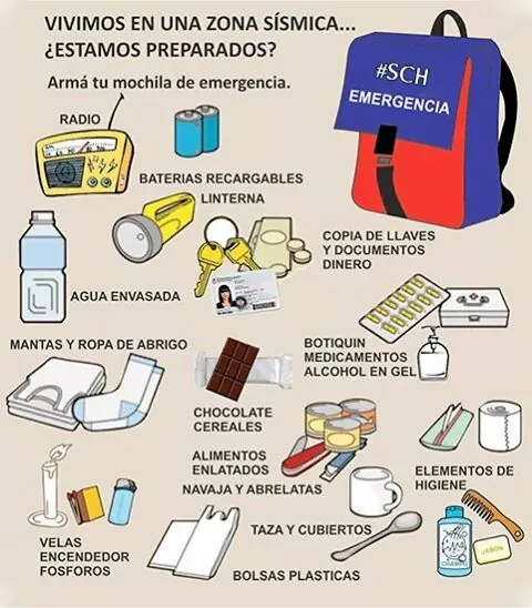
What should my emergency backpack have?
It should contain the essentials to survive the first hours after an earthquake:
– Hygiene items
– First aid kit with bandages, alcohol, gauze, pills, among others
– Warm clothing
– Non-perishable food such as tuna, energy bars, chocolates, and nuts, as well as cash
– Radio or flashlight with batteries
– Specific items according to needs, such as products for babies, elderly, or pets
What to do after an earthquake?
Check for injured people, turn off gas and electricity leaks, avoid using the elevator, and stay away from damaged structures. If you are in a coastal area, check for tsunami alerts.
Why does the Earth shake?
Because tectonic plates move and accumulate energy. When this energy is suddenly released, an earthquake occurs.
What is the difference between earthquake, tremor, quake, and seismic movement?
They are synonyms, but in some countries “earthquake” is used for the most destructive quakes.
Read more Colombia Elections 2026: Abelardo de la Espriella votes in Barranquilla surrounded by a crowd
Earthquake 47 km W of Mina Collahuasi
Local Time: 16:40:55 29/05/2026
UTC Time: 20:40:55 29/05/2026
Latitude: -20.86
Longitude: -69.11
Depth: 108 km
Magnitude: 2.9 MLv
Earthquake 104 km NE of El Salvador
Local Time: 18:17:21 29/05/2026
UTC Time: 22:17:21 29/05/2026
Latitude: -25.66
Longitude: -68.81
Depth: 100 km
Magnitude: 2.5 MLv
Earthquake 24 km SE of Curicó
Local Time: 16:36:11 29/05/2026
UTC Time: 20:36:11 29/05/2026
Latitude: -35.12
Longitude: -71.04
Depth: 98 km
Magnitude: 3.8 MLv
Why are multiple magnitudes reported for the same earthquake?
Because the first information comes from nearby stations and is adjusted as more data arrives from different sensors. Science continues calculating after the first alert.
How to differentiate a tremor from an earthquake?
Both are movements of the Earth, but we usually call “earthquake” those of greater magnitude and destructive impact, while “tremor” is used for milder quakes.
How do we know when an earthquake will happen?
Earthquakes cannot be predicted, but seismographs and accelerographs detect ground movements in real time to alert us as quickly as possible.
- Why is the duration of earthquakes not published?
Earthquakes have a duration of energy propagation at the seismic source, or hypocenter. However, once the waves leave the source, having different speeds, they separate from each other. For this reason, the perception of the duration of an earthquake will vary from place to place just as intensity does.
- Earthquake 70 km NW of Tocopilla
- Local Time 15:57:40 29/05/2026
- UTC Time 19:57:40 29/05/2026
- Latitude -21.54
- Longitude -70.52
- Depth 48 km
- Magnitude 4.1 MLv
- Earthquake 75 km W of San Antonio de los Cobres
- Local Time 15:38:48 29/05/2026
- UTC Time 19:38:48 29/05/2026
- Latitude -24.13
- Longitude -67.05
- Depth 184 km
- Magnitude 3.1 MLv
- Remember to have your “emergency backpack” with all its accessories and in a suitable place to use it in case of emergency
- Earthquake 83 km W of San Antonio de los Cobres
- Local Time 14:19:24 29/05/2026
- UTC Time 18:19:24 29/05/2026
- Latitude -23.97
- Longitude -67.09
- Depth 182 km
- Magnitude 3.3 MLv
- Earthquake 81 km SE of Socaire
- Local Time 13:33:32 29/05/2026
- UTC Time 17:33:32 29/05/2026
- Latitude -24.00
- Longitude -67.23
- Depth 221 km
- Magnitude 3.6 MLv
- What to do in case of an earthquake
The National Disaster Prevention and Response Service (Senapred) provided some recommendations on how to act during a significant seismic event.
These are the suggestions given by Senapred:
- Stay calm and seek a seismic protection place.
- Protect yourself under a sturdy object. If not possible, stay beside the same object.
- Cut off electrical power and close water and gas valves.
- If you are on the street, stay away from buildings, poles, and electrical wires.
- If you are at a mass event, the person should stay in place and protect the head and neck with arms. Also, follow the instructions of the venue’s security personnel.
- If driving in a tunnel, bridge, or highway, reduce speed and stop after leaving the place
- Earthquake 57 km SE of Camiña
- Local Time 12:28:36 29/05/2026
- UTC Time 16:28:36 29/05/2026
- Latitude -19.75
- Longitude -69.14
- Depth 84 km
- Magnitude 2.5 MLv
- Earthquake 111 km E of San Pedro de Atacama
- Local Time 12:12:31 29/05/2026
- UTC Time 16:12:31 29/05/2026
- Latitude -22.57
- Longitude -67.18
- Depth 124 km
- Magnitude 2.7 MLv
- Earthquake 84 km SE of Socaire
- Local Time 12:03:27 29/05/2026
- UTC Time 16:03:27 29/05/2026
- Latitude -24.05
- Longitude -67.24
- Depth 198 km
- Magnitude 3.4 MLv
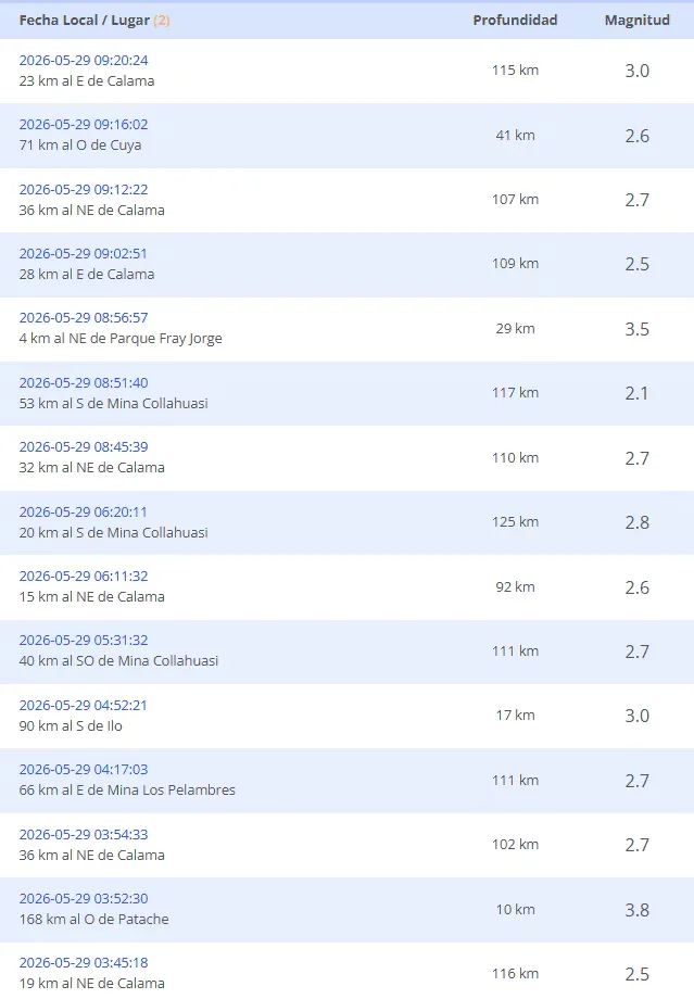
- Earthquake 20 km E of Calama
- Local Time 11:42:34 29/05/2026
- UTC Time 15:42:34 29/05/2026
- Latitude -22.43
- Longitude -68.74
- Depth 105 km
- Magnitude 2.5 MLv
- Earthquake 48 km S of Mina Collahuasi
- Local Time 11:20:03 29/05/2026
- UTC Time 15:20:03 29/05/2026
- Latitude -21.24
- Longitude -68.78
- Depth 120 km
- Magnitude 2.8 MLv
- Earthquake 145 km NW of Punta de Choros
- Local Time 11:15:29 29/05/2026
- UTC Time 15:15:29 29/05/2026
- Latitude -28.59
- Longitude -72.75
- Depth 28 km
- Magnitude 3.8 MLv
- Earthquake 40 km SW of Ollagüe
- Local Time 10:51:36 29/05/2026
- UTC Time 14:51:36 29/05/2026
- Latitude -21.48
- Longitude -68.52
- Depth 115 km
- Magnitude 2.5 MLv
- Earthquake 38 km SE of Pica
- Local Time 10:37:35 29/05/2026
- UTC Time 14:37:35 29/05/2026
- Latitude -20.80
- Longitude -69.18
- Depth 105 km
- Magnitude 3.1 MLv
- Earthquake 27 km SW of Navidad
- Local Time 10:37:12 29/05/2026
- UTC Time 14:37:12 29/05/2026
- Latitude -34.13
- Longitude -72.04
- Depth 43 km
- Magnitude 2.7 MLv
- Earthquake 23 km E of Calama
- Local Time 09:20:24 29/05/2026
- UTC Time 13:20:24 29/05/2026
- Latitude -22.51
- Longitude -68.71
- Depth 115 km
- Magnitude 3.0 MLv
- Earthquake 71 km W of Cuya
- Local Time 09:16:02 29/05/2026
- UTC Time 13:16:02 29/05/2026
- Latitude -18.96
- Longitude -70.82
- Depth 41 km
- Magnitude 2.6 MLv
- Earthquake 36 km NE of Calama
- Local Time 09:12:22 29/05/2026
- UTC Time 13:12:22 29/05/2026
- Latitude -22.25
- Longitude -68.66
- Depth 107 km
- Magnitude 2.7 MLv
- Earthquake 28 km E of Calama
- Local Time 09:02:51 29/05/2026
- UTC Time 13:02:51 29/05/2026
- Latitude -22.41
- Longitude -68.67
- Depth 109 km
- Magnitude 2.5 MLv
UPDATED EARTHQUAKE RECORDS:
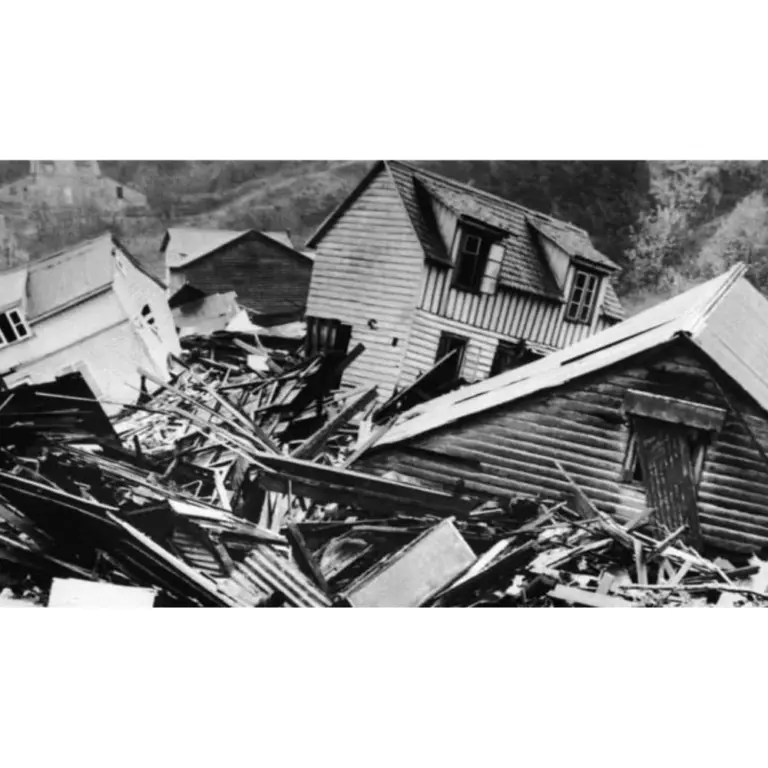
- WHAT IS THE LARGEST MAGNITUDE EARTHQUAKE RECORDED IN CHILE?
The earthquake on May 22, 1960, recorded in Valdivia with a magnitude of 9.5 is the strongest earthquake recorded in the country.
- WHAT IS THE PACIFIC RING OF FIRE?
The Pacific Ring of Fire is a geologically active region surrounding the Pacific Ocean and the continents bordering its waters. It is characterized by a high frequency of earthquakes and volcanic activity. It extends approximately 40,000 kilometers, including subduction zones where tectonic plates collide (such as the Nazca plate), generating frequent volcanoes and earthquakes.
- WHAT IS SEISMIC SILENCE?
Seismic silence is a prolonged period without significant seismic activity or intensity in a region, which may indicate the accumulation of tectonic stresses and an increased risk of a future earthquake.
- WHY IS CHILE A HIGHLY SEISMIC COUNTRY?
Chile is located on the western edge of the South American plate, where the Nazca and Antarctic plates converge and generate earthquakes. This is one of the zones of the Ring of Fire.
- WHAT IS THE DIFFERENCE BETWEEN MAGNITUDE AND INTENSITY OF AN EARTHQUAKE?
They are scales to measure the size or impact of a tremor. The magnitude scale is obtained numerically from records by seismographs and relates to the size and energy released during a tremor. The intensity scale is assigned based on the damage or effects caused to people and their constructions.
- WHAT TO DO IN CASE OF A TSUNAMI?
If you receive official tsunami alert or alarm information or see the sea receding, evacuate to higher areas. Move to a flood-free zone and head to the nearest meeting point. If you cannot reach a higher area, go to an upper floor or the roof of a solid building.
Follow live reports of the latest earthquakes in Chile recorded by the National Seismological Center. Also check related news and recommendations for acting in these types of situations.
Read more Horoscope for TODAY, Sunday, May 31: predictions according to your zodiac sign