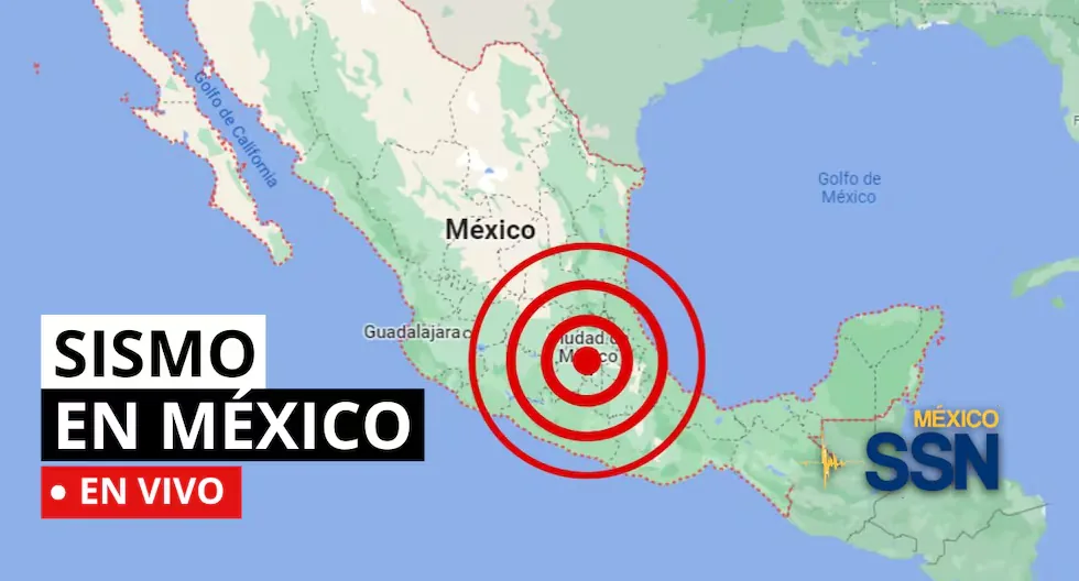









EARTHQUAKE IN MEXICO VIA THE NATIONAL SEISMOLOGICAL SERVICE
In the context of Plate Tectonics, Mexico is located in the so-called Ring of Fire, where a large part of the seismic movements worldwide are recorded. The country is located on the North American Plate, bordered on its southern and western portion by the Cocos, Rivera, and Pacific plates.
Read more TODAY’s Horoscope, Tuesday, July 28: love and money forecasts according to your zodiac sign
Mexico is one of the countries in the world with the highest seismic activity, as according to statistics, more than 90 earthquakes per year with a magnitude greater than 4 on the Richter scale are recorded, which is equivalent to 60% of all seismic movements recorded worldwide.
Based on statistical records, the states with the highest risk and where large magnitude earthquakes that can affect Mexico City occur are: Jalisco, Colima, Michoacán, Guerrero, Oaxaca, Puebla, State of Mexico, and Veracruz.
Earthquake 107 km to the SOUTHWEST of CD HIDALGO, CHIS
Magnitude 4.3
Date: 2026-07-28
Time: 0:09:16 (Central Time)
Latitude: 14.066º
Longitude: -92.917º
Depth: 6.9 km
Earthquake 91 km to the SOUTHWEST of CD HIDALGO, CHIS
Magnitude 4.2
Date: 2026-07-27
Time: 23:52:26 (Central Time)
Latitude: 14.084º
Longitude: -92.729º
Depth: 10.0 km
Earthquake 116 km to the SOUTHWEST of CD HIDALGO, CHIS
Magnitude 4.0
Date: 2026-07-27
Time: 23:51:00 (Central Time)
Latitude: 13.982º
Longitude: -92.95º
Depth: 10.5 km
Earthquake 130 km to the SOUTHWEST of CD HIDALGO, CHIS
Magnitude 4.2
Date: 2026-07-27
Time: 23:43:39 (Central Time)
Latitude: 13.756º
Longitude: -92.899º
Depth: 10.0 km
Earthquake 113 km to the SOUTHWEST of CD HIDALGO, CHIS
Magnitude 5.9
Date: 2026-07-27
Time: 23:35:16 (Central Time)
Latitude: 14.009º
Longitude: -92.949º
Depth: 12.4 km
Earthquake 90 km to the SOUTHWEST of PINOTEPA NACIONAL, OAX
Magnitude 3.3
Date: 2026-07-27
Time: 16:37:42 (Central Time)
Latitude: 15.664º
Longitude: -98.521º
Depth: 5.3 km
Earthquake 106 km to the SOUTHWEST of CD HIDALGO, CHIS
Magnitude 4.0
Date: 2026-07-27
Time: 16:31:09 (Central Time)
Latitude: 14.31º
Longitude: -93.056º
Depth: 18.3 km
How to know if an earthquake is strong?
There are two ways:
– Magnitude, measured on the Richter scale, indicates the energy released.
– Intensity, measured on the Mercalli scale, measures the impact on people and structures.
What should my emergency backpack have?
It should contain the essentials to survive the first hours after an earthquake:
– Hygiene items
– First aid kit with bandages, alcohol, gauze, pills, among others
– Warm clothing
– Non-perishable food such as tuna, energy bars, chocolates, and nuts, as well as cash
– Radio or flashlight with batteries
– Specific items according to needs, such as products for babies, elderly, or pets
How to differentiate a tremor from an earthquake?
Both are movements of the Earth, but we usually call “earthquake” those of greater magnitude and destructive impact, while “tremor” is used for milder quakes.
Why are several magnitudes reported for the same earthquake?
Because the first information comes from nearby stations and is adjusted as more data arrives from different sensors. Science continues calculating after the first alert.
How do we know an earthquake is going to happen?
Earthquakes cannot be predicted, but seismographs and accelerographs detect ground movements in real time to alert us as quickly as possible.
What to do if I am on the street when an earthquake starts?
Look for an open place away from poles, trees, or buildings. Beware of electrical wires. If you are driving, stop carefully in a safe place.
- How much should the survival backpack weigh?
The ideal weight should not exceed 25% of the body weight of the person who will carry it, ensuring a quick and agile evacuation.
- Can earthquakes be predicted with current technology?
No. The date, place, and magnitude of an earthquake cannot be predicted. Only long-term statistical probability estimates can be made in certain areas.
- What are the functions of the Seismological Service in Mexico?
The functions of the SSN include:
Collecting, analyzing, and disseminating information about seismic activity in Mexico.
Generating reports on seismic activity in Mexico.
Issuing seismic alerts.
Developing and operating early seismic warning systems.
Conducting scientific research on seismology.
Training personnel in seismology.
- What number to call in case of earthquakes in Mexico?
In case of an earthquake in Mexico, the emergency numbers to call are:
Emergency service: 911
Civil Protection Secretariat: 56 83 22 22
Police: 060
Red Cross: 065 and 53 95 11 11
Firefighters: 57 68 25 32
Locatel: 56 58 11 11
- What should my emergency backpack have?
It should contain the essentials to survive the first hours after an earthquake:
Read more Monumental Museum: prices, tour, and how to visit the historic house of Universitario
– Hygiene items
– First aid kit with bandages, alcohol, gauze, pills, among others
– Warm clothing
– Non-perishable food such as tuna, energy bars, chocolates, and nuts, as well as cash
– Radio or flashlight with batteries
– Specific items according to needs, such as products for babies, elderly, or pets
The Seismic Alert activates automatically when stations installed on the coast of Guerrero detect the start of a large magnitude earthquake and send the signal.
Initially, alert notices were broadcast through the Personalized Seismic Alert System (SASPER); installed in some schools, government buildings, and emergency institutions. Currently, we can timely warn the population at seismic risk with alert notices broadcast through special regional radio stations, whose signal allows the automatic operation of economical receivers designed to warn of natural hazards called the Mexican Risk Warning System
As of 08:00 hours on 27/July/2026, 1,038 aftershocks of the M 7.4 earthquake that occurred in Ciudad Hidalgo, Chiapas on 17/July/2026 have been recorded, the largest with a magnitude of M 6.5.
- WHY YOU SHOULD NEVER USE AN ELEVATOR DURING AN EARTHQUAKE?
Experts recommend never using the elevator during an earthquake or tremor, as it could detach from its structure and fall from a great height with people inside.
- Earthquake 142 km southwest of Ciudad Hidalgo, Chiapas
Magnitude: 4.2
Date: 27/07/26
Time: 06:01:34
Latitude: 14.10
Longitude: -93.32
Depth: 16 km
- Earthquake 144 km southwest of Ciudad Hidalgo, Chiapas
Magnitude: 4.2
Date: 26/07/26
Time: 23:55:40
Latitude: 14.02
Longitude: -93.31
Depth: 15 km
- As of 20:00 hours on 26/July/2026, 1,003 aftershocks of the M 7.4 earthquake that occurred in Ciudad Hidalgo, Chiapas on 17/July/2026 have been recorded, the largest with a magnitude of M 6.5.
- EARTHQUAKE 138 km to the SOUTHWEST of CD HIDALGO, CHIAPAS
- Magnitude 4.2
- Date: 2026-07-26
- Time: 20:13:40 (Central Time)
- Latitude: 14.154º
- Longitude: -93.315º
- Depth: 10.0 km
- EARTHQUAKE 132 km to the SOUTHWEST of CD HIDALGO, CHIAPAS
- Magnitude 4.2
- Date: 2026-07-26
- Time:19:39:00 (Central Time)
- Latitude: 14.17º
- Longitude: -93.255º
- Depth: 10.7 km
- EARTHQUAKE 26 km to the WEST of PINOTEPA NACIONAL, OAXACA
- Magnitude 4.2
- Date: 2026-07-26
- Time: 18:56:38 (Central Time)
- Latitude: 16.328º
- Longitude: -98.294º
- Depth: 10.5 km
- Can earthquakes be predicted with current technology?
No. The date, place, and magnitude of an earthquake cannot be predicted. Only long-term statistical probability estimates can be made in certain areas.
- What number to call in case of earthquakes in Mexico?
In case of an earthquake in Mexico, the emergency numbers to call are:
- Emergency service: 911
- Civil Protection Secretariat: 56 83 22 22
- Police: 060
- Red Cross: 065 and 53 95 11 11
- Firefighters: 57 68 25 32
- Locatel: 56 58 11 11
It is important to note that, in case of an earthquake, telephone lines may become saturated. Therefore, it is recommended to use emergency lines only in real emergencies.
- Earthquake 69 km northeast of Matías Romero, Oaxaca
Magnitude: 4.1
Date: 26/07/26
Time: 14:40:41
Latitude: 17.21
Longitude: -94.49
Depth: 136 km
- Earthquake 59 km south of Tonala, Chiapas
Magnitude: 4.2
Date: 26/07/26
Time: 11:58:29
Latitude: 15.66
Longitude: -93.71
Depth: 97 km
- Earthquake 59 km northwest of La Mira, Michoacán
Magnitude: 4.0
Date: 26/07/26
Time: 11:09:21
Latitude: 18.47
Longitude: -102.66
Depth: 3 km
- Earthquake 148 km southwest of Ciudad Hidalgo, Chiapas
Magnitude: 4.2
Date: 26/07/26
Time: 10:32:51
Latitude: 14.07
Longitude: -93.38
Depth: 10 km
- Earthquake 42 km southwest of Mapastepec, Chiapas
Magnitude: 4.1
Date: 26/07/26
Time: 09:54:05
Latitude: 15.15
Longitude: -93.15
Depth: 26 km
- Earthquake 58 km southeast of Ciudad Hidalgo, Chiapas
Magnitude: 4.5
Date: 26/07/26
Time: 09:34:04
Latitude: 14.47
Longitude: -91.66
Depth: 10 km
- Earthquake 133 km south of Ciudad Hidalgo, Chiapas
Magnitude: 4.3
Date: 26/07/26
Time: 08:48:21
Latitude: 13.51
Longitude: -92.43
Depth: 3 km
- Earthquake 45 km southwest of Mapastepec, Chiapas
Magnitude: 4.1
Date: 26/07/26
Time: 06:23:35
Latitude: 15.25
Longitude: -93.27
Depth: 67 km
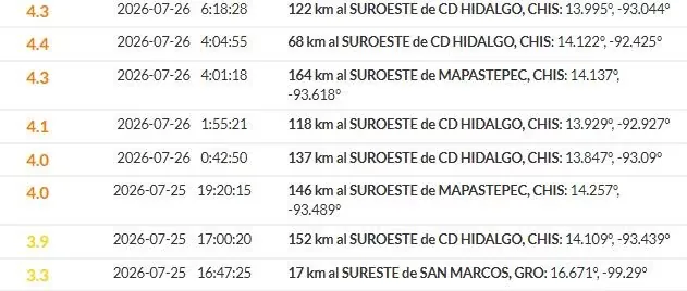
Earthquake 45 km to the SOUTHWEST of MAPASTEPEC
- Date and Local Time: 2026-07-26 6:23:35
- Magnitude: 4.1
- Depth: 67.3 km
- Latitude: 15.251
- Longitude: -93.267
Recent earthquakes reported by the SSN.
- WHAT IS THE LARGEST MAGNITUDE EARTHQUAKE THAT SHOOK MEXICO CITY?
- On September 19, 1985, Mexico City experienced a devastating earthquake of 8.1 magnitude, with its epicenter on the Pacific coast.
- It is estimated that at least 10,000 people lost their lives, affecting and collapsing thousands of housing, commercial, and public service structures.
- WHAT IS AN EARTHQUAKE?
An earthquake is a sudden rupture of rocks inside the Earth. This sudden release of energy propagates in the form of waves that cause ground movement.
- HOW LONG DOES AN EARTHQUAKE LAST AND WHY DOES THE SSN NOT REPORT THIS DATA?
When we talk about the duration of an earthquake, we can refer to several different concepts: One is the duration of the movement perceived by humans, another is the duration of the instrumental record (which can be several minutes), and another is the time the fault movement that caused the earthquake lasted (which can be just a few seconds).
- WHAT IS THE DIFFERENCE BETWEEN THE MAGNITUDE AND INTENSITY OF AN EARTHQUAKE?
They are scales to measure the size or impact of a tremor. The magnitude scale is obtained numerically from records obtained by seismographs and is related to the size and energy released during a tremor. The intensity scale is assigned based on the damage or effects caused to people and their constructions.
Mexico is one of the countries in the world with the highest seismic activity, as according to statistics, more than 90 earthquakes per year with a magnitude greater than 4 on the Richter scale are recorded, which is equivalent to 60% of all seismic movements recorded worldwide.
What was the magnitude and where was the last earthquake in Mexico? See live here the reports from the National Seismological Service (SSN) about earthquakes in the country.
Read more Miguel Uccelli Labarthe resigns from the position of general manager of Citibank Peru