![Alberto Beingolea: “If they insist on not giving [the powers], they are complicating life for Peru”](https://insightermedia.com/wp-content/uploads/2026/09/bb3fa9e11304ea13fe2cd333955007bc-150x150.webp "Alberto Beingolea: “If they insist on not giving [the powers], they are complicating life for Peru”")



Follow live all seismic movements in the country, according to the reports published by the Geophysical Institute of Peru. Also check news related to this, as well as recommendations in these types of situations.
Read more Today, Comerciantes Unidos vs FC Cajamarca LIVE: time and where to watch the Clausura Tournament
Earthquake in Peru via the IGP
- Earthquake 166 km SE of Tacna, Tacna – Tacna
- Local Date and Time: 28/08/2026 12:53:26
- Magnitude: 4.2
- Depth: 102km
- Latitude: -19.28
- Longitude: -69.41
- Intensity: II-III Tacna
- WHAT TO DO BEFORE AN EARTHQUAKE?
- Locate safe zones and sturdy structures to protect yourself.
- Have an emergency backpack ready.
- Participate in earthquake drills in your neighborhood.
- Educate the children in your home about precautionary measures.
- Hire an engineer to reinforce your home.
- WHAT TO DO DURING AN EARTHQUAKE?
- Stay calm. Getting scared can only paralyze you or cause you to make mistakes.
- Stay away from windows and objects that may fall.
- If you cannot quickly reach the exit, find a safe space.
- Do not call by phone. The line will be overloaded, so it is better to send text messages.
- Do not use the elevator.
- WHAT TO DO AFTER AN EARTHQUAKE?
- Check for gas leaks that could cause fire.
- Call emergency numbers such as: firefighters 116, Red Cross (01) 2660481 and the Mobile Emergency Care System (SAMU) 106.
- Assist the injured.
- Be careful with possible aftershocks. Avoid being near houses that have been affected by the earthquake.
- If you are near the sea, move away from the area until the possibility of a tsunami is ruled out.
- In the event of a large magnitude earthquake, remember to avoid calling landlines or cell phones, as this causes saturation of mobile lines; opt to write text messages.
- HOW ARE EARTHQUAKE DATA OBTAINED IN PERU?
CENSIS obtains its data from the National Seismic Network (DS-0017-2018MINAM), composed and integrated by a series of velocity, acceleration, and displacement sensors distributed throughout the country.
- WHY IS PERU A HIGHLY SEISMIC ZONE?
Peru is a highly seismic country because it is located within the Pacific Ring of Fire.
- Earthquake Reference: 11 km S of Chilca, Cañete – Lima
- Local Date and Time: 28/08/2026 08:19:54
- Magnitude: 3.4
- Depth: 48km
- Latitude: -12.61
- Longitude: -76.77
- Intensity: II Chilca
- EARTHQUAKE 21 KM SE OF VITOR, AREQUIPA – AREQUIPA.
- • Local Date and Time: 27/08/2026,23:55:03
- • Magnitude: 3.4
- • Depth: 15 km
- • Latitude: -16.56
- • Longitude: -71.77
- • Intensity: II Vitor
- EARTHQUAKE 21 KM SE OF VITOR, AREQUIPA – AREQUIPA.
SEISMIC REPORT:
— National Seismological Center (@Sismos_Peru_IGP) August 28, 2026
IGP/CENSIS/RS 2026-0601
Local Date and Time: 27/08/2026,23:55:03
Magnitude: 3.4
Depth: 15 km
Latitude: -16.56
Longitude: -71.77
Intensity: II Vitor
Reference: 21 km SE of Vitor, Arequipa – Arequipahttps://t.co/fmyFqs5WAU
- WHY IS PERU A HIGHLY SEISMIC COUNTRY?
Peru is located on the western edge of South America, the region with the highest seismic activity in the world, and therefore it is necessary to understand the probable behavior of this hazard in a given area in order to plan and mitigate the effects that could occur in the future. The way to understand this behavior is through seismic hazard assessment.
- WHAT TO DO IF YOU HAVE A PET?
It is recommended that they have a collar with their name and address to avoid getting lost, as well as registering them with your district municipality. You can designate a family member to calm your pet and take care of its move to a safe area, but without risking their life. Also, include pet food, a leash, and a blanket to keep them warm in the emergency backpack.
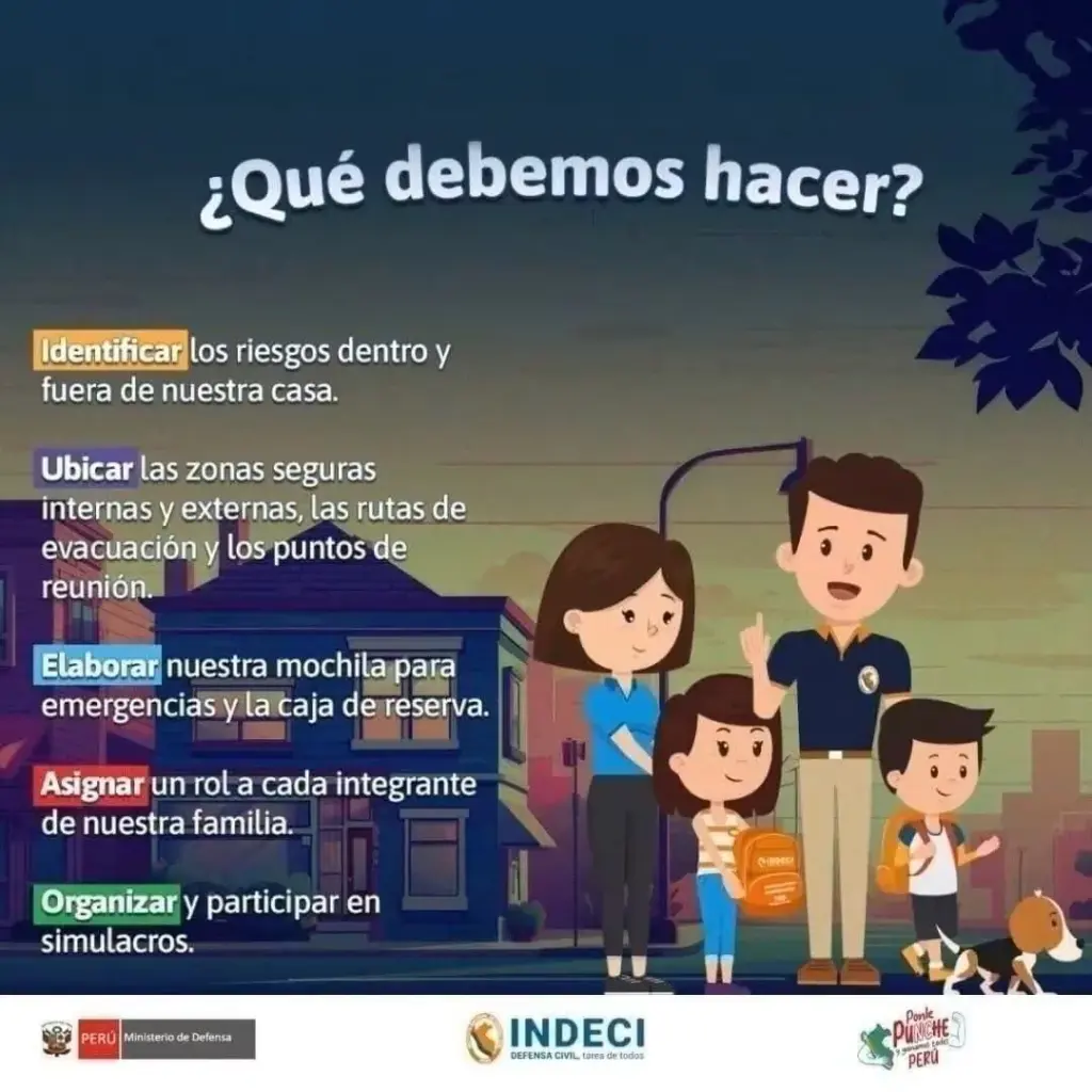
Prepare your Family Emergency Plan by assigning roles to each family member.
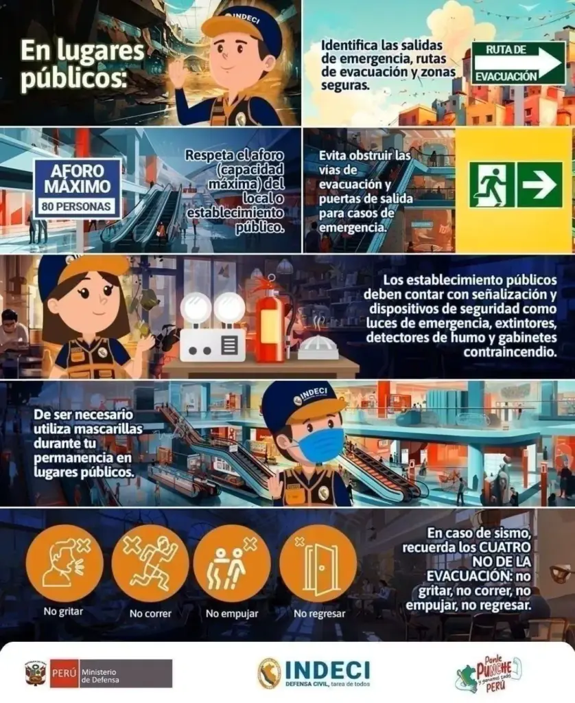
Identify evacuation routes, respect capacity limits, avoid blocking exits, and recognize safety devices.
An emergency can happen at any time.

- How to activate Google’s earthquake early warning
- Go to the Settings of your mobile device.
- Go to Emergencies.
- Scroll to where it says “Earthquake Alerts”.
- WHY SHOULD YOU NEVER USE AN ELEVATOR DURING AN EARTHQUAKE?
Experts recommend never using the elevator during an earthquake or tremor, as it could detach from its structure and fall from a great height with people inside.
- Where do most earthquakes occur in Peru?
- Áncash
- Ica
- Lima
- Arequipa
- Moquegua
- Tacna
- WHAT IS THE PACIFIC RING OF FIRE?
- The Pacific Ring of Fire is a geologically active region surrounding the Pacific Ocean and the continents bordering its waters. It is characterized by a high frequency of earthquakes and volcanic activity. It extends approximately 40,000 kilometers, including subduction zones where tectonic plates collide (such as the Nazca Plate), generating frequent volcanoes and earthquakes.
- WHAT IS SEISMIC SILENCE?
- Seismic silence is a prolonged period without significant seismic activity or intensity in a region, which may indicate the accumulation of tectonic stresses and an increased risk of a future earthquake.
- EARTHQUAKE 26 KM NE OF CAMANÁ, CAMANÁ – AREQUIPA.
- • Local Date and Time: 27/08/2026,15:18:56
- • Magnitude: 3.5
- • Depth: 58 km
- • Latitude: -16.41
- • Longitude: -72.62
- • Intensity: II-III Camaná
- EARTHQUAKE 26 KM NE OF CAMANÁ, CAMANÁ – AREQUIPA.
SEISMIC REPORT:
— National Seismological Center (@Sismos_Peru_IGP) August 27, 2026
IGP/CENSIS/RS 2026-0600
Local Date and Time: 27/08/2026,15:18:56
Magnitude: 3.5
Depth: 58 km
Latitude: -16.41
Longitude: -72.62
Intensity: II-III Camaná
Reference: 26 km NE of Camaná, Camaná – Arequipahttps://t.co/wOauXSaduz
- WHAT IS AN EARTHQUAKE?
- An earthquake is a sudden breaking of rocks inside the Earth. This sudden release of energy propagates as waves that cause ground movement.
- Earthquake 26 km NE of Camaná, Camaná – Arequipa
- Local Date and Time: 27/08/2026 15:18:56
- Magnitude: 3.5
- Depth: 58km
- Latitude: -16.41
- Longitude: -72.62
- Intensity: II-III Camaná
- Earthquake 13 km W of La Capilla, General Sánchez Cerro – Moquegua
- Date:27/08/2026 13:34:03
- Magnitude: 3.5
- Depth: 18km
- Latitude:- 16.80
- Longitude: – 71.29
- WHAT TO DO IN CASE OF A TSUNAMI?
- If you receive official tsunami alert or alarm information or see the sea receding, evacuate to higher areas. Move to a flood-free zone and head to the nearest meeting point. If you cannot reach a higher area, go to an upper floor or the roof of a solid building.
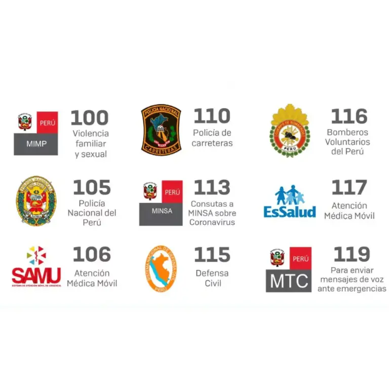
- CHECK AND WRITE DOWN EMERGENCY ASSISTANCE NUMBERS.
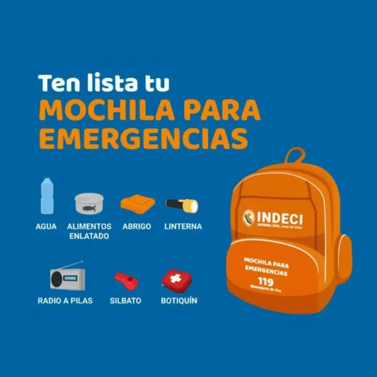
- WHAT SHOULD MY EMERGENCY BACKPACK CONTAIN?
- • Essential hygiene items
- • First aid kit (bandages, gauze, alcohol, pills, hydrogen peroxide, etc.)
- • Warm clothing
- • Non-perishable food (tuna cans, cereal bars, chocolates, nuts, etc.) and money
- • Communication items
- • Specific items for babies and infants, feminine use, elderly, and other basic needs.
- CHECK WHAT AN EMERGENCY BACKPACK FOR THE HOME SHOULD CONTAIN.
- EARTHQUAKE 37 KM NE OF ZARUMILLA, ZARUMILLA – TUMBES.
- • Local Date and Time: 27/08/2026,12:23:23
- • Magnitude: 4.2
- • Depth: 40 km
- • Latitude: -3.21
- • Longitude: -80.10
- • Intensity: II-III Zarumilla
- EARTHQUAKE 37 KM NE OF ZARUMILLA, ZARUMILLA – TUMBES.
SEISMIC REPORT:
IGP/CENSIS/RS 2026-0597
Local Date and Time: 27/08/2026,12:23:23
Magnitude: 4.2
Depth: 40 km
Latitude: -3.21
Longitude: -80.10
Intensity: II-III Zarumilla
Reference: 37 km NE of Zarumilla, Zarumilla – Tumbeshttps://t.co/6lF6k0pN6VRead more Peruvian doctor Edgar Amorín Kajatt closes an important chapter in his professional life
— National Seismological Center (@Sismos_Peru_IGP) August 27, 2026
- EARTHQUAKE 22 KM NW OF ZORRITOS, CONTRALMIRANTE VILLAR – TUMBES.
- • Local Date and Time: 27/08/2026,12:09:25
- • UTC Date and Time: 27/08/2026,17:09:25
- • Magnitude: 4.7
- • Depth: 40 km
- • Latitude: -3.59
- • Longitude: -80.84
- EARTHQUAKE 22 KM NW OF ZORRITOS, CONTRALMIRANTE VILLAR – TUMBES.
SEISMIC REPORT:
— National Seismological Center (@Sismos_Peru_IGP) August 27, 2026
IGP/CENSIS/RS 2026-0596
Local Date and Time: 27/08/2026,12:09:25
UTC Date and Time: 27/08/2026,17:09:25
Magnitude: 4.7
Depth: 40 km
Latitude: -3.59
Longitude: -80.84
Intensity: III-IV Zorritos
Reference: 22 km NW of Zorritos, Contralmirante Villar – Tumbes…
- EARTHQUAKE 16 KM SW OF LA CAPILLA, GENERAL SÁNCHEZ CERRO – MOQUEGUA.
- • Local Date and Time: 27/08/2026,08:21:34
- • Magnitude: 3.5
- • Depth: 20 km
- • Latitude: -16.83
- • Longitude: -71.31
- • Intensity: II-III La Capilla
- EARTHQUAKE 16 KM SW OF LA CAPILLA, GENERAL SÁNCHEZ CERRO – MOQUEGUA.
SEISMIC REPORT:
— National Seismological Center (@Sismos_Peru_IGP) August 27, 2026
IGP/CENSIS/RS 2026-0595
Local Date and Time: 27/08/2026,08:21:34
Magnitude: 3.5
Depth: 20 km
Latitude: -16.83
Longitude: -71.31
Intensity: II-III La Capilla
Reference: 16 km SW of La Capilla, General Sánchez Cerro – Moqueguahttps://t.co/tkRC73HoI4
- EARTHQUAKE 63 KM SW OF PIMENTEL, CHICLAYO – LAMBAYEQUE.
- • Local Date and Time: 26/08/2026,23:04:18
- • Magnitude: 4.4
- • Depth: 26 km
- • Latitude: -7.14
- • Longitude: -80.42
- • Intensity: III Pimentel
- EARTHQUAKE 63 KM SW OF PIMENTEL, CHICLAYO – LAMBAYEQUE.
SEISMIC REPORT:
— National Seismological Center (@Sismos_Peru_IGP) August 27, 2026
IGP/CENSIS/RS 2026-0594
Local Date and Time: 26/08/2026,23:04:18
Magnitude: 4.4
Depth: 26 km
Latitude: -7.14
Longitude: -80.42
Intensity: III Pimentel
Reference: 63 km SW of Pimentel, Chiclayo – Lambayequehttps://t.co/kQysQlDprh
- EMERGENCY PHONE NUMBERS – PERU
- • Emergency line: 105
- (It is the national single emergency line, allowing Peruvians to access all emergency and security services with just one number).
- • National Police: 105
- • Firefighters: 116
- • Highway Police: 110
- • Civil Defense: 115
- • Infosalud: 113
- • Red Cross: 01 266 0481
- • SAMU Ambulance Service: 106
- WHY IS PERU A HIGHLY SEISMIC COUNTRY?
- Peru is located on the western edge of South America, the region with the highest seismic activity in the world, and therefore it is necessary to understand the probable behavior of this hazard in a given area in order to plan and mitigate the effects that could occur in the future. The way to understand this behavior is through seismic hazard assessment.
- HOW ARE EARTHQUAKE DATA OBTAINED IN PERU?
- CENSIS obtains its data from the National Seismic Network (DS-0017-2018MINAM), composed and integrated by a series of velocity, acceleration, and displacement sensors distributed throughout the country.
WHAT IS THE LARGEST MAGNITUDE EARTHQUAKE RECORDED BY INSTRUMENTS IN PERU?
On Thursday, October 3, 1974, an 8.0 magnitude earthquake was recorded in Lima at 9:21 a.m., striking the capital of Peru as well as much of the Peruvian coast to the south. The movement lasted about 90 seconds and resulted in 252 deaths and 3,600 injuries.
Peru is located in a seismic zone and the occurrence of earthquakes is inevitable. A study by the IGP indicates that seismic energy is accumulated in the south of the country, which should encourage participation in drills.
The entity responsible for recording every tremor in the country is the Geophysical Institute of Peru (IGP). It also provides official information every time an earthquake occurs through its social media accounts.
HOW ARE EARTHQUAKE DATA OBTAINED IN PERU?
CENSIS obtains its data from the National Seismic Network (DS-0017-2018MINAM), composed and integrated by a series of velocity, acceleration, and displacement sensors distributed throughout the country.
WHY IS PERU A HIGHLY SEISMIC ZONE?
Peru is a highly seismic country because it is located within the Pacific Ring of Fire.
Check here the latest records from the Geophysical Institute of Peru on seismic movements in the country.
Read more Pataz: three injured, businesses and boats damaged after landslide in Pías lagoon