![Alberto Beingolea: “If they insist on not giving [the powers], they are complicating life for Peru”](https://insightermedia.com/wp-content/uploads/2026/09/bb3fa9e11304ea13fe2cd333955007bc-150x150.webp "Alberto Beingolea: “If they insist on not giving [the powers], they are complicating life for Peru”")



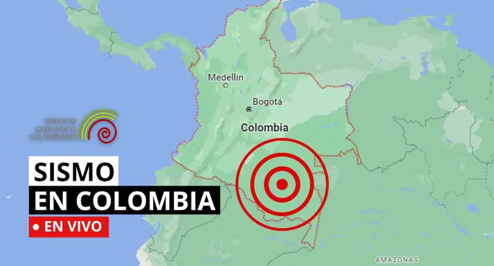
Earthquake in Colombia via the Geological Service
The SGC has a total of 339 seismic stations, located throughout the Colombian territory and in specific areas such as active volcanoes. 206 seismic stations are located covering the entire territory corresponding to the National Seismic Network and 133 seismic stations installed on the active Colombian volcanoes that are permanently monitored in three volcanological and seismological observatories.
Find out here about the earthquakes that occurred in Colombian territory, reported by the Geological Service. Here we tell you which were the latest.
- Earthquake in Piedecuesta – Santander, Colombia
- Magnitude: 2.6
- Depth: 132 km
- Local time: 2026-08-31 10:03:52
- UTC time: 2026-08-31 15:03:52
- Latitude: 6.97°
- Longitude: -73.08°
- Earthquake in Istmina – Chocó, Colombia
- Magnitude: 2.8
- Depth: Shallow (Less than 70 km)
- Local time: 2026-08-31 09:29:31
- UTC time: 2026-08-31 14:29:31
- Latitude: 4.52°
- Longitude:-76.96°
- Earthquake in Piedecuesta – Santander, Colombia
- Magnitude: 2.1
- Depth: 144 km
- Local time: 2026-08-31 08:30:46
- UTC time: 2026-08-31 13:30:46
- Latitude: 6.82°
- Longitude:-72.93°
- UPDATED EARTHQUAKE REPORTS:
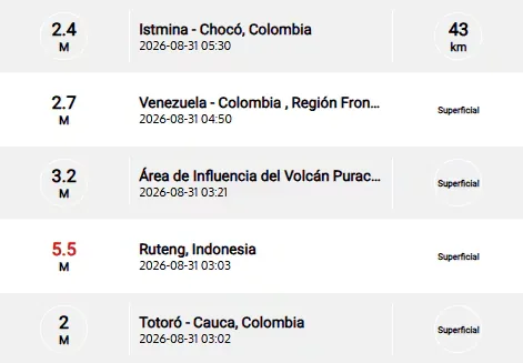
Earthquake in Tarazá – Antioquia, Colombia
Magnitude: 2.1
Depth: Shallow (Less than 30 km)
Local time: 2026-08-30 22:30:47
UTC time: 2026-08-31 03:30:47
Latitude: 7.40°
Longitude: -75.62°
Earthquake in Totoró – Cauca, Colombia
Magnitude: 2.5
Depth: Shallow (Less than 30 km)
Local time: 2026-08-30 21:43:54
UTC time: 2026-08-31 02:43:54
Latitude: 2.40°
Longitude: -76.33°
Earthquake in Riohacha – La Guajira, Colombia
Magnitude: 2.1
Depth: 66 km
Local time: 2026-08-30 20:52:11
UTC time: 2026-08-31 01:52:11
Latitude: 11.05°
Longitude: -73.30°
Earthquake in Los Santos – Santander, Colombia
Magnitude: 2.9
Depth: 141 km
Local time: 2026-08-30 19:17:55
UTC time: 2026-08-31 00:17:55
Latitude: 6.82°
Longitude: -73.14°
How to know if an earthquake is strong?
There are two ways:
– Magnitude, measured on the Richter scale, indicates the energy released.
– Intensity, measured on the Mercalli scale, measures the impact on people and structures.
What should my emergency backpack have?
It should contain the essentials to survive the first hours after an earthquake:
– Hygiene items
– First aid kit with bandages, alcohol, gauze, pills, among others
– Warm clothing
– Non-perishable food such as tuna, energy bars, chocolates, and nuts, as well as cash
– Radio or flashlight with batteries
– Specific items according to needs, such as products for babies, elderly, or pets
What to do after an earthquake?
Check for injured people, turn off gas and electricity leaks, avoid using the elevator, and stay away from damaged structures. If you are in a coastal area, check for tsunami alerts.
Why does the Earth shake?
Because tectonic plates move and accumulate energy. When this energy is released suddenly, an earthquake occurs.
How to prepare before an earthquake?
Conduct drills, have your emergency backpack ready, and plan an evacuation route with your family. Prevention saves lives.
What is the difference between earthquake, tremor, quake, and seismic movement?
They are synonyms, but in some countries “earthquake” is used for the most destructive quakes.
- Which institution records earthquakes in Colombia?
- The Colombian Geological Service, through the National Seismological Network of Colombia, monitors seismic activity in the national territory.
- Earthquake in the Area of Influence of the Galeras Volcano
- Magnitude: 2.2
- Depth: Shallow (Less than 30 km)
- Local time: 2026-08-30 13:48:37
- UTC time: 2026-08-30 18:48:37
- Latitude: 1.29°
- Longitude:-77.42°
- Where can I check the latest earthquakes?
- The SGC has an official earthquake viewer where seismic activity recorded in Colombia can be consulted.
- Why does it shake so much in Colombia?
- Seismic activity is related to the complex interaction of tectonic plates and the numerous fault systems present in Colombian territory.
- It should be remembered that the first data of an earthquake are preliminary. After a more detailed review of the signals captured by the monitoring network, parameters such as magnitude, depth, or epicenter location may be adjusted. For this reason, the most recent information disseminated by the SGC should be considered the current official reference.
- Earthquake in Los Santos – Santander, Colombia
- Magnitude: 3.5
- Depth: 153 km
- Local time: 2026-08-30 13:04:42
- UTC time: 2026-08-30 18:04:42
- Latitude: 6.82°
- Longitude:-73.09°
- The geological faults that explain part of the earthquakes in Colombia
- Colombia has numerous geological fault systems. Among the best-known structures are the Bucaramanga-Santa Marta fault, the Romeral fault, the Algeciras fault, and other systems associated with the deformation of the Andes.
- These structures allow the energy accumulated in the Earth’s crust to be released through seismic movements.
- Earthquake in Hobo – Huila, Colombia
- Magnitude: 2.3
- Depth: Shallow (Less than 30 km)
- Local time: 2026-08-30 11:08:38
- UTC time: 2026-08-30 16:08:38
- Latitude: 2.48°
- Longitude:-75.42°
- Earthquake in Dabeiba – Antioquia, Colombia
- Magnitude: 2.5
- Depth: Shallow (Less than 30 km)
- Local time: 2026-08-30 10:30:34
- UTC time: 2026-08-30 15:30:34
- Latitude: 6.99°
- Longitude:-76.29°
- Why does it shake so much in Colombia?
- The answer has much to do with the place on the planet where we are, since our country is located in the Pacific Ring of Fire, an extensive strip that surrounds the Pacific Ocean and concentrates much of the world’s seismic and volcanic activity.
- This location is related to active tectonic dynamics. In western Colombia, among other processes, the subduction of the Nazca plate under the South American plate occurs. This interaction is part of the natural processes that generate crust deformation, giving rise to large structures such as mountain ranges and the presence of fault systems.
- Earthquake in Cimitarra – Santander
- Local Date and Time: 2026-08-30 09:22
- Magnitude: 2.1
- Depth: shallow
- Latitude: 6.32
- Longitude: -73.92
- Earthquake in Istmina – Chocó
- Local Date and Time: 2026-08-30 09:17
- Magnitude: 2.9
- Depth: 36 km
- Latitude: 4.47
- Longitude: -76.77
Recent earthquakes reported by the SGC.
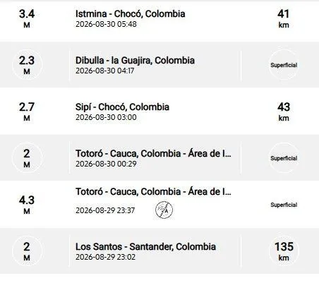
Why does the Earth shake?
Because tectonic plates move and accumulate energy. When this energy is released suddenly, an earthquake occurs.
How to know if an earthquake is strong?
There are two ways:
– Magnitude, measured on the Richter scale, indicates the energy released.
– Intensity, measured on the Mercalli scale, measures the impact on people and structures.
What should my emergency backpack have?
It should contain the essentials to survive the first hours after an earthquake:
Read more Buse, pre-US Open training: latest news from New York
– Hygiene items
– First aid kit with bandages, alcohol, gauze, pills, among others
– Warm clothing
– Non-perishable food such as tuna, energy bars, chocolates, and nuts, as well as cash
– Radio or flashlight with batteries
– Specific items according to needs, such as products for babies, elderly, or pets
How is a tremor different from an earthquake?
Both are movements of the Earth, but we usually call “earthquake” those of greater magnitude and destructive impact, while “tremor” is used for milder quakes.
Why are several magnitudes reported for the same earthquake?
Because the first information comes from nearby stations and is adjusted as more data arrives from different sensors. Science continues calculating after the first notice.
How do we know it will shake?
Earthquakes cannot be predicted, but seismographs and accelerographs detect ground movements in real time to alert us as quickly as possible.
What to do if I am on the street when an earthquake starts?
Look for an open place away from poles, trees, or buildings. Beware of electrical wires. If you are driving, stop carefully in a safe place.
In the event of a large magnitude earthquake, remember to avoid calling landlines or cell phones, as this causes saturation in mobile lines; opt to send text messages.
- Earthquake in the Area of Influence of the Galeras Volcano
- Local Date and Time: 2026-08-29 13:35
- Magnitude: 2.7
- Depth: shallow
- Latitude: 1.25
- Longitude: -77.34
- Earthquake in Pueblo Rico – Risaralda
- Local Date and Time: 2026-08-29 13:24
- Magnitude: 2.6
- Depth: 63 km
- Latitude: 5.22
- Longitude: -76.06
- Earthquake in Istmina – Chocó
- Local Date and Time: 2026-08-29 12:28
- Magnitude: 2.5
- Depth: shallow
- Latitude: 4.49
- Longitude: -76.85
- Earthquake in Santa Helena del Opón
- Local Date and Time: 2026-08-29 12:16
- Magnitude: 2.4
- Depth: 104 km
- Latitude: 6.43
- Longitude: -73.57
- Earthquake in Guaca – Santander
- Local Date and Time: 2026-08-29 12:09
- Magnitude: 2.7
- Depth: 122 km
- Latitude: 6.81
- Longitude: -72.91
- Earthquake in Medio San Juan
- Local Date and Time: 2026-08-29 10:33
- Magnitude: 3.5
- Depth: 37 km
- Latitude: 4.56
- Longitude: -76.75
- Earthquake in Sipí – Chocó
- Local Date and Time: 2026-08-29 08:58
- Magnitude: 3.1
- Depth: 41 km
- Latitude: 4.39
- Longitude: -76.71
- Earthquake in Sipí – Chocó
- Local Date and Time: 2026-08-29 08:06
- Magnitude: 2
- Depth: 32 km
- Latitude: 4.55
- Longitude: -76.66
Recent earthquakes reported by the SGC.
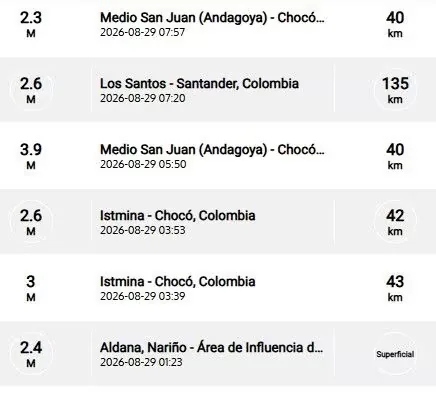
WHAT IS THE DIFFERENCE BETWEEN EARTHQUAKE, TREMOR, QUAKE, AND SEISMIC MOVEMENT?
In reality, the four terms are synonyms, but in Latin America special emphasis has been given to the term earthquake to be assigned to destructive quakes or those that have caused victims.
HOW MANY SEISMOGRAPHS ARE THERE?
NATIONAL SEISMOLOGICAL NETWORK OF COLOMBIA-RSNC
The SGC has a total of 339 seismic stations, located throughout the Colombian territory and in specific areas such as active volcanoes. 206 seismic stations are located covering the entire territory corresponding to the National Seismic Network.
There are 133 seismic stations installed on the active Colombian volcanoes that are permanently monitored in three volcanological and seismological observatories.
WHAT IS THE COLOMBIAN GEOLOGICAL SERVICE?
The SGC is a century-old science and technology entity attached to the Ministry of Mines and Energy, whose objective is to contribute to the country’s economic and social development through research in basic and applied geosciences of the subsurface, the potential of its resources, the evaluation and monitoring of geological hazards, the comprehensive management of geoscientific knowledge, research and nuclear and radioactive control, addressing the priorities of the National Government’s policies.
What was the magnitude and where was the last tremor? See here the reports from the Colombian Geological Service (SGC) about the latest earthquakes in the country.
Read more El Niño is the ‘brief’