![Alberto Beingolea: “If they insist on not giving [the powers], they are complicating life for Peru”](https://insightermedia.com/wp-content/uploads/2026/09/bb3fa9e11304ea13fe2cd333955007bc-150x150.webp "Alberto Beingolea: “If they insist on not giving [the powers], they are complicating life for Peru”")



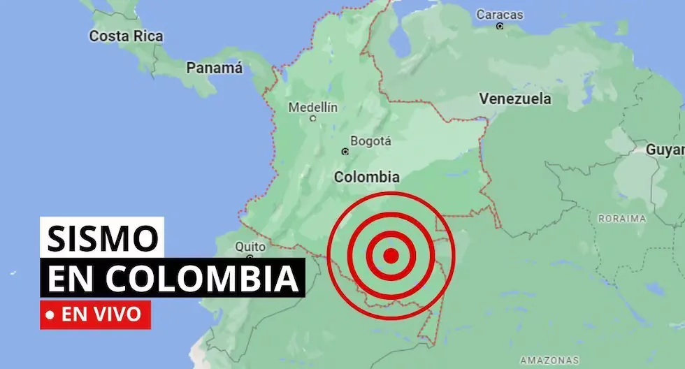
Earthquake in Colombia via the Geological Service
The SGC has a total of 339 seismic stations, located throughout the Colombian territory and in specific areas such as active volcanoes. 206 seismic stations are located covering the entire territory corresponding to the National Seismic Network and 133 seismic stations installed on the active Colombian volcanoes that are permanently monitored in three volcanological and seismological observatories.
Read more Do you want to travel abroad? Discover the destinations you can visit with a Peruvian passport
Find out here about the earthquakes that occurred in Colombian territory, reported by the Geological Service. Here we tell you which were the latest.
- WHAT IS SEISMIC SILENCE?
- Seismic silence is a prolonged period without significant seismic activity or of significant intensity in a region, which may indicate the accumulation of tectonic stresses and an increased risk of a future earthquake.
- WHAT IS A SEISMIC SWARM?
- A seismic swarm is a group of earthquakes that occur in the same area over a short period of time. Unlike a single strong earthquake, seismic swarms usually consist of numerous minor tremors. Often, there is no main earthquake triggering the swarm, but the seismic events occur more or less continuously and are related to tectonic processes.
- Earthquake in Istmina – Chocó, Colombia
- Magnitude: 2.3
- Depth: 40 km
- Local time: 2026-08-14 12:17
- Latitude: 4.50°
- Longitude:-76.69°
- HOW TO ACT DURING AN EARTHQUAKE?
- • Go to the already established safety zones.
- • Stay away from glass or objects that could fall.
- • If possible, avoid panic and try to stay calm.
- • Do not run in vehicle passage areas.
- • If you are driving, stop your vehicle.
- • If you are in a building, do not use the elevator, always use the stairs.
- • Be attentive to minors, disabled people, and the elderly.
- HOW TO DIFFERENTIATE A TREMOR FROM AN EARTHQUAKE?
- The terms “tremor” and “earthquake” are often used interchangeably, but generally, the difference lies in their magnitude, perceived intensity, and reach.
- • Tremor: Refers to seismic movements of lesser intensity. Usually, it is used to describe low magnitude earth tremors that do not cause significant damage to structures or people. They are perceptible, but their impact is mild.
- • Earthquake: Refers to a seismic event of greater magnitude. Earthquakes are significant seismic tremors that can cause severe damage to buildings, infrastructure, and, in the most severe cases, cause personal injuries and even loss of life. They have considerable magnitude and are often accompanied by aftershocks.
- Earthquake in Los Santos – Santander, Colombia
- Magnitude: 3.5
- Depth: 145 km
- Local time: 2026-08-14 14:43
- Latitude: 6.81°
- Longitude:-73.12°
- Earthquake in Piedecuesta – Santander, Colombia
- Magnitude: 2.0
- Depth: 150 km
- Local time: 2026-08-14 08:48
- Latitude: 6.89°
- Longitude:-73.02°
- WHAT IS THE PACIFIC RING OF FIRE?
- The Pacific Ring of Fire is a geologically active region that surrounds the Pacific Ocean and the continents that border its waters. It is characterized by a high frequency of earthquakes and volcanic activity. It extends approximately 40,000 kilometers, including subduction zones where tectonic plates collide (such as the Nazca plate), generating frequent volcanoes and earthquakes.
- WHY SHOULD YOU NEVER USE AN ELEVATOR DURING AN EARTHQUAKE?
- Experts recommend never using the elevator during an earthquake or tremor, as it could detach from its structure and fall from a great height with people inside.
- WHAT IS AN EARTHQUAKE?
- An earthquake is a sudden rupture of rocks inside the Earth. This sudden release of energy propagates in the form of waves that cause ground movement.
- WHAT TO DO IN CASE OF A TSUNAMI?
- If you receive official tsunami alert or alarm information or see the sea receding, evacuate to higher areas. Move to a flood-free zone and head to the nearest meeting point. If you cannot reach a high area, go to an upper floor or the roof of a solid building.
- CHECK AND NOTE THE EMERGENCY ASSISTANCE NUMBER.

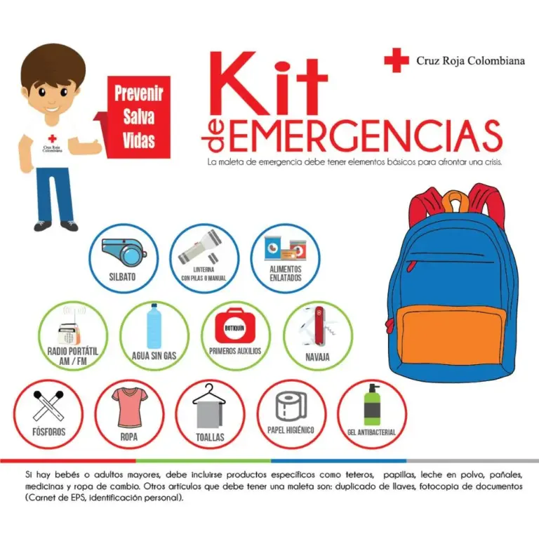
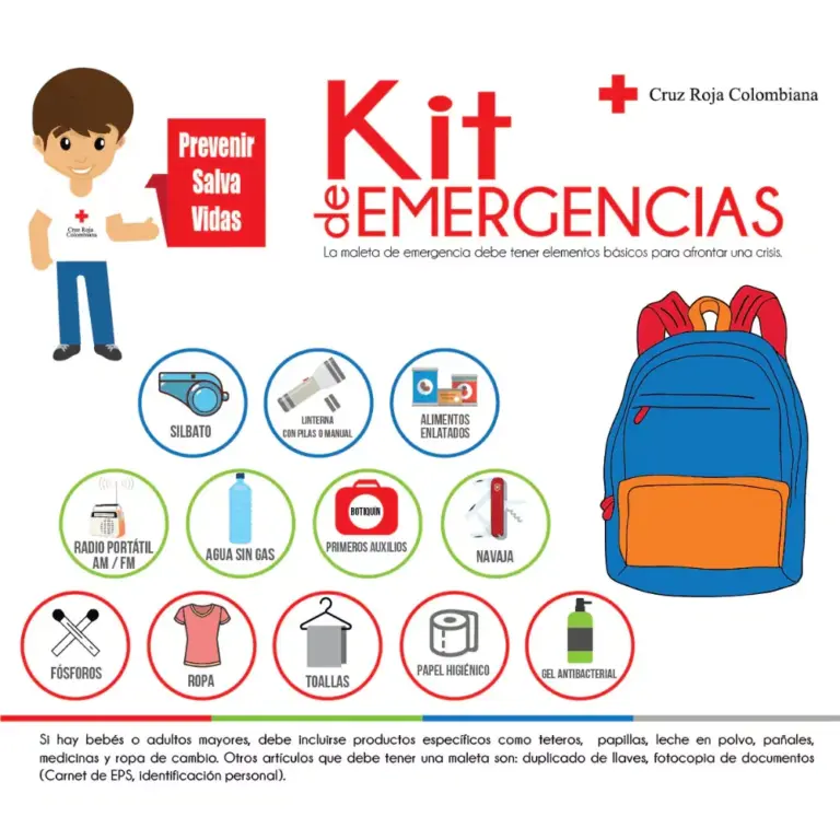
- WHAT SHOULD MY EMERGENCY BACKPACK CONTAIN?
- • Essential hygiene items
- • First aid kit (bandages, gauze, alcohol, pills, hydrogen peroxide, etc.)
- • Warm clothing
- • Non-perishable food (tuna cans, cereal bars, chocolates, nuts, etc.) and money
- • Communication items
- • Specific items for babies and infants, feminine use, elderly, and other basic needs.
- CHECK WHAT A HOME EMERGENCY BACKPACK SHOULD CONTAIN.
- WHY ARE THERE SO MANY EARTHQUAKES IN COLOMBIA?
- Colombia is located in the northwestern corner of South America, where the South American, Nazca, and Caribbean tectonic plates converge; a characteristic that explains the high level of seismicity in the country.
- EMERGENCY PHONE NUMBERS – COLOMBIA
- • Emergency line: 123
- (It is the national single emergency line, allowing Colombians to access all emergency and security services offered by the State with just one number)
- • National Police: 112
- • Traffic Police: 127
- • Civil Defense: 144
- • Firefighters: 119
- • Red Cross: 132
- • Ambulance Service: 125
- • Gaula – Anti-kidnapping: 165
- • Disaster Attention: 111
- CAN EARTHQUAKES BE PREDICTED?
- So far, there is no reliable technique anywhere in the world for earthquake forecasting, and we are still far from achieving it.
- However, although earthquakes cannot be predicted in time, they can be predicted in space, meaning in certain areas it can be said that an earthquake will occur, but when it will happen is unknown.
- Earthquake in Caribbean Sea
Magnitude: 2.3
Depth: Shallow (Less than 70 km)
Local time: 2026-08-14 09:06:36
UTC time: 2026-08-14 14:06:36
Latitude: 11.08°
Longitude: -74.69°
- Earthquake in Istmina – Chocó, Colombia
Magnitude: 3.2
Depth: Shallow (Less than 30 km)
Local time: 2026-08-14 08:08:09
UTC time: 2026-08-14 13:08:09
Latitude: 4.47°
Longitude: -76.74°
- Earthquake in Los Santos – Santander, Colombia
Magnitude: 2.8
Depth: 141 km
Local time: 2026-08-14 07:00:38
UTC time: 2026-08-14 12:00:38
Latitude: 6.82°
Longitude: -73.07°
- San Juan Coast (Docordó) – Chocó, Colombia
Magnitude: 3
Depth: 58 km
Local time: 2026-08-14 05:45:00
UTC time: 2026-08-14 10:45:00
Latitude: 4.15°
Longitude: -76.80°
- BREAKING | • At this hour, the president of Colombia Abelardo de la Espriella confirmed that the number of deaths from the earthquake has risen to 281, 3,971 injured, 379 missing, and 102,105 affected people.
- Earthquake in San Juan Coast (Docordó) – Chocó, Colombia
- Magnitude: 3.1
- Depth: Shallow (Less than 30 km)
- Local time: 2026-08-13 21:26:47
- UTC time: 2026-08-14 02:26:47
- Latitude: 4.34°
- Longitude:-76.69°
- Earthquake in Los Santos – Santander, Colombia
- Magnitude: 3
- Depth: 155 km
- Local time: 2026-08-13 20:27:26
- UTC time: 2026-08-14 01:27:26
- Latitude: 6.83°
- Longitude:-73.12°
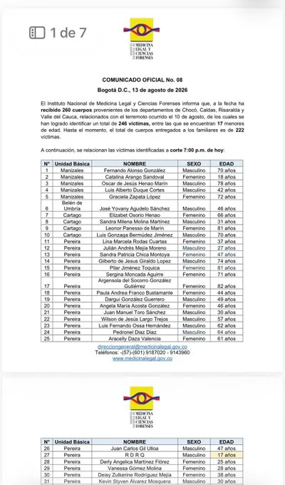
- The number of victims identified by the National Institute of Legal Medicine and Forensic Sciences increased to 246 after the earthquake. Among them are 17 minors. So far, 222 bodies have been handed over to their families.
- Earthquake in Istmina – Chocó, Colombia
- Magnitude: 2.8
- Depth: Shallow (Less than 70 km)
- Local time: 2026-08-13 20:09:42
- UTC time: 2026-08-14 01:09:42
- Latitude: 4.43°
- Longitude:-76.72°
- Earthquake in Los Santos – Santander, Colombia
- Magnitude: 2
- Depth: 134 km
- Local time: 2026-08-13 17:31:44
- UTC time: 2026-08-13 22:31:44
- Latitude: 6.81°
- Longitude:-73.18°
- Can earthquakes be predicted?
- To date, there is no technique that allows predicting earthquakes. Not even countries like the United States and Japan, whose technology is very advanced, have been able to develop a predictive technique for tremors. Since we live in a country with high seismic activity, the only certainty we have is that it shakes constantly and that we must be prepared. In the face of any seismic event, the only thing that can help us is prevention.
- New UNGRD report as of 5:00 pm on August 13.
- The earthquake leaves 281 dead, 3,971 injured, 379 missing, and 348 rescued.
- The emergency already affects 15 departments and 426 municipalities, with 44,936 families and 102,105 affected people.
- In housing, 10,677 are reported destroyed and 65,841 damaged. Additionally, 243 animals were affected and 169 have already been rescued.
- The National Institute of Legal Medicine and Forensic Sciences reported that 228 bodies of earthquake victims that shook Colombia have already been identified. Of these, 13 are minors. A total of 194 bodies have been handed over to their families.
- Earthquake in Istmina – Chocó, Colombia
- Magnitude: 2.5
- Depth: 42 km
- Local time: 2026-08-13 16:42:20
- UTC time: 2026-08-13 21:42:20
- Latitude: 4.50°
- Longitude: -76.69°
- Earthquake in Mariquita – Tolima, Colombia
- Magnitude: 2.3
- Depth: 128 km
- Local time: 2026-08-13 16:10:46
- UTC time: 2026-08-13 21:10:46
- Latitude: 5.19°
- Longitude:-74.87°
- Earthquake in Sipí – Chocó, Colombia
- Magnitude: 2.4
- Depth: Shallow (Less than 30 km)
- Local time: 2026-08-13 15:45:19
- UTC time: 2026-08-13 20:45:19
- Latitude: 4.62°
- Longitude:-76.68°
- • Earthquake: Refers to a seismic event of greater magnitude. Earthquakes are significant seismic tremors that can cause severe damage to buildings, infrastructure, and, in the most severe cases, cause personal injuries and even loss of life. They have considerable magnitude and are often accompanied by aftershocks.
- Earthquake in Armenia – Antioquia, Colombia
- Magnitude: 2.2
- Depth: 124km
- Time: 2026-08-13 14:59
- Longitude: 6.23°
- Latitude: -75.86°
- WHAT IS THE PACIFIC RING OF FIRE?
- The Pacific Ring of Fire is a geologically active region that surrounds the Pacific Ocean and the continents that border its waters. It is characterized by a high frequency of earthquakes and volcanic activity. It extends approximately 40,000 kilometers, including subduction zones where tectonic plates collide (such as the Nazca plate), generating frequent volcanoes and earthquakes.
- WHAT TO DO IN CASE OF A TSUNAMI?
- If you receive official tsunami alert or alarm information or see the sea receding, evacuate to higher areas. Move to a flood-free zone and head to the nearest meeting point. If you cannot reach a high area, go to an upper floor or the roof of a solid building.
- CHECK AND NOTE THE EMERGENCY ASSISTANCE NUMBER.

- WHAT SHOULD MY EMERGENCY BACKPACK CONTAIN?
- • Essential hygiene items
- • First aid kit (bandages, gauze, alcohol, pills, hydrogen peroxide, etc.)
- • Warm clothing
- • Non-perishable food (tuna cans, cereal bars, chocolates, nuts, etc.) and money
- • Communication items
- • Specific items for babies and infants, feminine use, elderly, and other basic needs.
- CHECK WHAT A HOME EMERGENCY BACKPACK SHOULD CONTAIN.
- WHY ARE THERE SO MANY EARTHQUAKES IN COLOMBIA?
- Colombia is located in the northwestern corner of South America, where the South American, Nazca, and Caribbean tectonic plates converge; a characteristic that explains the high level of seismicity in the country.
- EMERGENCY PHONE NUMBERS – COLOMBIA
- • Emergency line: 123
- (It is the national single emergency line, allowing Colombians to access all emergency and security services offered by the State with just one number)
- • National Police: 112
- • Traffic Police: 127
- • Civil Defense: 144
- • Firefighters: 119
- • Red Cross: 132
- • Ambulance Service: 125
- • Gaula – Anti-kidnapping: 165
- • Disaster Attention: 111
- Earthquake in San José del Palmar – Chocó, Colombia
- Magnitude: 4.2
- Depth: 95km
- Time: 2026-08-13 09:42
- Longitude: 4.86°
- Latitude: -76.41°
- Earthquake in Frontino – Antioquia, Colombia
- Magnitude: 2.6
- Depth: Shallow
- Time: 2026-08-13 09:08
- Longitude: 6.81°
- Latitude: -76.27°
- Earthquake in Nóvita – Chocó, Colombia
- Magnitude: 3.6
- Depth: 94km
- Time: 2026-08-13 06:22
- Longitude: 4.86°
- Latitude: -76.54°
- Earthquake in Sipí – Chocó, Colombia
- Magnitude: 2.4
- Depth: 113km
- Time: 2026-08-13 02:57
- Longitude: 4.63°
- Latitude: -76.59°
- Earthquake in San José del Palmar – Chocó, Colombia
- Magnitude: 2.6
- Depth: 87km
- Time: 2026-08-13 01:03
- Longitude: 4.86°
- Latitude: -76.44°
- CAN EARTHQUAKES BE PREDICTED?
- So far, there is no reliable technique anywhere in the world for earthquake forecasting, and we are still far from achieving it.
- However, although earthquakes cannot be predicted in time, they can be predicted in space, meaning in certain areas it can be said that an earthquake will occur, but when it will happen is unknown.
- WHAT IS THE DIFFERENCE BETWEEN EARTHQUAKE, TREMOR, SEISM, AND TELURIC MOVEMENT?
In reality, the four terms are synonyms, but in Latin America special emphasis has been given to the term earthquake to refer to destructive seismic events or those that have caused victims.
- HOW MANY SEISMOGRAPHS ARE THERE?
NATIONAL SEISMIC NETWORK OF COLOMBIA-RSNC
The SGC has a total of 339 seismic stations, located throughout the Colombian territory and in specific areas such as active volcanoes. 206 seismic stations are located covering the entire territory corresponding to the National Seismic Network.
Read more The day Lima stopped: the 1974 earthquake that marked an entire generation | PHOTOS
There are 133 seismic stations installed on the active Colombian volcanoes that are permanently monitored in three volcanological and seismological observatories.
- WHAT IS THE COLOMBIAN GEOLOGICAL SERVICE?
The SGC is a century-old science and technology entity attached to the Ministry of Mines and Energy, whose objective is to contribute to the country’s economic and social development through research in basic and applied geosciences of the subsurface, the potential of its resources, the evaluation and monitoring of geological hazards, the comprehensive management of geoscientific knowledge, research, and nuclear and radioactive control, addressing the priorities of the National Government’s policies.
What was the magnitude and where was the last tremor? See here the reports from the Colombian Geological Service (SGC) about the latest earthquakes in the country.
Read more Argentina: 62-year-old woman becomes a mother for the first time after fertility treatment