![Alberto Beingolea: “If they insist on not giving [the powers], they are complicating life for Peru”](https://insightermedia.com/wp-content/uploads/2026/09/bb3fa9e11304ea13fe2cd333955007bc-150x150.webp "Alberto Beingolea: “If they insist on not giving [the powers], they are complicating life for Peru”")



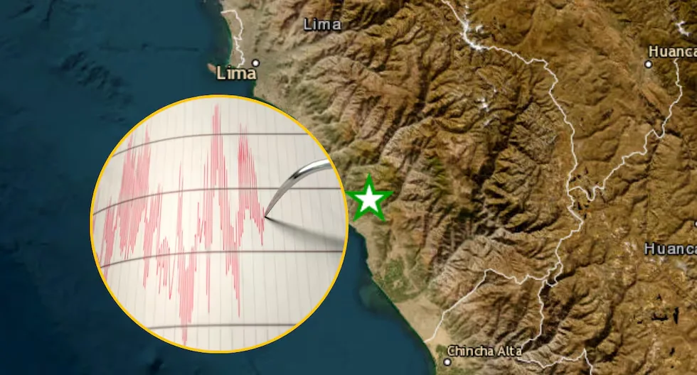
Check the latest earthquakes recorded in Peru according to IGP reports. The Peruvian territory is located in an area with a high propensity for seismic activity, as it is situated on the “Pacific Ring of Fire.” Following this logic, the country tends to shake continuously with varying magnitudes from the most imperceptible to large-scale earthquakes. These are the most feared by the resident population. The areas that usually report the most earthquakes are Ica, Arequipa, Lima, and other regions strategically located at the collision points of tectonic plates.
On the other hand, although the Peruvian region has a high risk factor for tremors and earthquakes, it is not the only country with this characteristic, but shares this factor with other neighboring South American countries. Likewise, with the Japanese country located on the other side of the Pacific, Japan.
Therefore, the Geophysical Institute of Peru constantly reports every earthquake recorded in the country with the aim of informing the population and monitoring seismic movements and promoting a culture of prevention together with INDECI to avoid future tragedies for millions of Peruvians.
Here we share with you the latest earthquake reports from the IGP:
SEISMIC REPORT:
— National Seismological Center (@Sismos_Peru_IGP) September 17, 2026
IGP/CENSIS/RS 2026-0673
Local Date and Time: 09/16/2026,22:26:53
Magnitude: 3.6
Depth: 35 km
Latitude: -4.90
Longitude: -80.78
Intensity: II-III Sullana
Reference: 10 km W of Sullana, Sullana – Piurahttps://t.co/BRQeNRFO44
SEISMIC REPORT:
— National Seismological Center (@Sismos_Peru_IGP) September 16, 2026
IGP/CENSIS/RS 2026-0672
Local Date and Time: 09/16/2026,01:38:32
Magnitude: 3.5
Depth: 16 km
Latitude: -16.40
Longitude: -71.58
Intensity: II-III Arequipa
Reference: 5 km W of Arequipa, Arequipa – Arequipahttps://t.co/GdmchbOxZ0
SEISMIC REPORT:
— National Seismological Center (@Sismos_Peru_IGP) September 16, 2026
IGP/CENSIS/RS 2026-0671
Local Date and Time: 09/15/2026,23:08:14
Magnitude: 4.2
Depth: 21 km
Latitude: -9.57
Longitude: -80.49
Reference: 217 km W of Chimbote, Santa – Áncashhttps://t.co/G4fG5CYAy4
SEISMIC REPORT:
— National Seismological Center (@Sismos_Peru_IGP) September 15, 2026
IGP/CENSIS/RS 2026-0670
Local Date and Time: 09/15/2026,10:30:38
Magnitude: 3.4
Depth: 42 km
Latitude: -11.85
Longitude: -77.56
Intensity: II-III Ancón
Reference: 43 km W of Ancón, Lima – Limahttps://t.co/n5ltpX1xOU
SEISMIC REPORT:
— National Seismological Center (@Sismos_Peru_IGP) September 15, 2026
IGP/CENSIS/RS 2026-0669
Local Date and Time: 09/14/2026,21:27:31
Magnitude: 4.0
Depth: 107 km
Latitude: -11.02
Longitude: -74.41
Reference: 35 km NE of Satipo, Satipo – Junínhttps://t.co/WCVX9djVfE
SEISMIC REPORT:
— National Seismological Center (@Sismos_Peru_IGP) September 14, 2026
IGP/CENSIS/RS 2026-0668
Local Date and Time: 09/14/2026,14:16:47
Magnitude: 4.8
Depth: 117 km
Latitude: -3.68
Longitude: -77.42
Intensity: III Andoas
Reference: 112 km W of Andoas, Datem del Marañón – Loretohttps://t.co/yiwQVuVXWV
SEISMIC REPORT:
IGP/CENSIS/RS 2026-0667
Local Date and Time: 09/14/2026,09:20:35
Magnitude: 3.9
Depth: 13 km
Latitude: -13.29
Longitude: -70.35
Intensity: III San Gabán
Reference: 17 km N of San Gabán, Carabaya – Punohttps://t.co/hwBbkF4l4CRead more This is how the U.S. bases were left after the attacks from Iran: how serious is the damage?
— National Seismological Center (@Sismos_Peru_IGP) September 14, 2026
SEISMIC REPORT:
— National Seismological Center (@Sismos_Peru_IGP) September 14, 2026
IGP/CENSIS/RS 2026-0666
Local Date and Time: 09/14/2026,07:46:02
Magnitude: 3.5
Depth: 12 km
Latitude: -13.29
Longitude: -70.35
Intensity: II-III San Gabán
Reference: 17 km N of San Gabán, Carabaya – Punohttps://t.co/3YF7h3JmI1
SEISMIC REPORT:
— National Seismological Center (@Sismos_Peru_IGP) September 14, 2026
IGP/CENSIS/RS 2026-0665
Local Date and Time: 09/14/2026,04:23:50
Magnitude: 4.0
Depth: 23 km
Latitude: -3.25
Longitude: -80.68
Intensity: II-III Tumbes
Reference: 43 km NW of Tumbes, Tumbes – Tumbeshttps://t.co/dwJb7ttnnC
SEISMIC REPORT:
— National Seismological Center (@Sismos_Peru_IGP) September 14, 2026
IGP/CENSIS/RS 2026-0664
Local Date and Time: 09/14/2026,03:22:48
Magnitude: 3.5
Depth: 15 km
Latitude: -13.33
Longitude: -70.31
Intensity: II-III San Gabán
Reference: 16 km NE of San Gabán, Carabaya – Punohttps://t.co/2qdC7kBvAd
SEISMIC REPORT:
— National Seismological Center (@Sismos_Peru_IGP) September 13, 2026
IGP/CENSIS/RS 2026-0663
Local Date and Time: 09/13/2026,18:12:37
Magnitude: 3.4
Depth: 15 km
Latitude: -17.16
Longitude: -70.76
Intensity: II Torata
Reference: 13 km SE of Torata, Mariscal Nieto – Moqueguahttps://t.co/ucdXfH1Nrn
SEISMIC REPORT:
— National Seismological Center (@Sismos_Peru_IGP) September 13, 2026
IGP/CENSIS/RS 2026-0662
Local Date and Time: 09/13/2026,17:12:24
Magnitude: 3.7
Depth: 58 km
Latitude: -13.11
Longitude: -76.67
Intensity: III San Vicente de Cañete
Reference: 31 km W of San Vicente de Cañete, Cañete – Limahttps://t.co/19GjJadIrr
SEISMIC REPORT:
— National Seismological Center (@Sismos_Peru_IGP) September 13, 2026
IGP/CENSIS/RS 2026-0661
Local Date and Time: 09/13/2026,17:01:09
Magnitude: 3.4
Depth: 46 km
Latitude: -11.75
Longitude: -77.54
Intensity: II Ancón
Reference: 41 km W of Ancón, Lima – Limahttps://t.co/i28wbst6sq
SEISMIC REPORT:
— National Seismological Center (@Sismos_Peru_IGP) September 13, 2026
IGP/CENSIS/RS 2026-0660
Local Date and Time: 09/13/2026,01:03:52
Magnitude: 3.5
Depth: 13 km
Latitude: -10.18
Longitude: -74.32
Intensity: II-III Puerto Bermúdez
Reference: 69 km E of Puerto Bermúdez, Oxapampa – Pascohttps://t.co/MkRueiSuQP
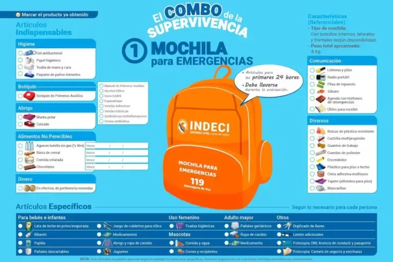
What items are essential for your emergency backpack?
Find out here what items your emergency backpack should contain:
- Hygiene items: antibacterial gel, toilet paper, toothbrush, hand and face towel, pack of wet wipes.
- First aid kit: masks, ethyl alcohol, sterile gauze, adhesive tape, adhesive bandages, elastic bandages, antibiotics, anti-inflammatories, and antibiotic cream. Include specific medications if any family member has a disease.
- Warmth: fleece blanket and footwear.
- Non-perishable food: bottled still water, cereal bar, canned food, and chocolates.
- Miscellaneous: multi-purpose knife, polyester ropes, lighter, adhesive tape, and plastic bags.
- Money and communication items: batteries, portable radio, whistle, and flashlight.
It is important to remember that you should replace the products periodically to ensure they have expiration dates within the stipulated time. On the other hand, citizens with pets are reminded to consider their needs and equip the necessary items in the emergency backpack.
Read more “United States has the technology, but the war with Iran reveals the limit of its arsenals”